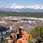
Monticello, Utah
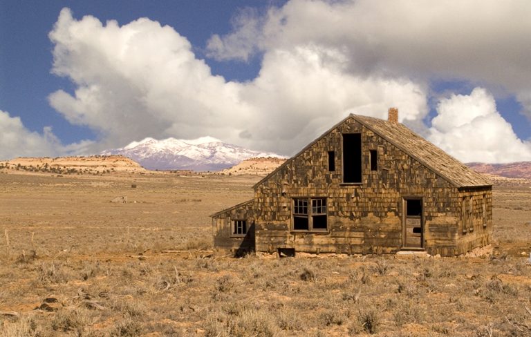
Monticello, Utah is one of the gateways to the Abajo Mountains. Situated on the east side of the famous Blue Mountains, Monticello offers stunning views and access to some of southwest Utah’s best backcountry skiing and fly fishing as well as phenomenal hiking, climbing, backpacking, mountain biking, and exploration. The town also has a stake, both in location and politics, in the controversial proposal for a Bears Ears National Monument. The potential boundary of the new 1.9-million-acre national monument would abut the town and engulf the Abajo Mountains, diminishing the expansive, open terrain currently available to the residents and visitors of Monticello. The city council even passed a resolution in opposition of new federal land, clearly outlining the state-federal battle currently being waged in the Four Corners. Regardless of the future designation, the surrounding land is full of adventure and Monticello is an excellent base to recharge after exploring the area’s treasures.
Recent Articles
-
The Battle for The Bears Ears, Part V: A Personal View
This is the fifth and final installment of a series of articles examining protection of Cedar Mesa and the proposed Bears Ears National Monument. On my first day as a ranger I climbed the Bears Ears. Visible more than 100 miles away from my home in New Mexico, they stood like two beacons above the desert, […]
-
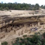
The Battle for The Bears Ears, Part IV: The Trouble With Archaeology
This is the fourth installment of a series of articles examining protection of Cedar Mesa and the proposed Bears Ears National Monument. When it comes to protecting the land, archaeology is the problem from hell. Ruins deteriorate and crumble away, vulnerable to animal disturbance, erosion, and weathering. Looters and vandals can destroy sites just as […]
-
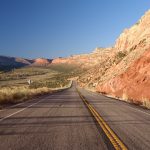
The Battle for The Bears Ears, Part III: Road Wars
This is the third installment of a series of articles examining protection of Cedar Mesa and the proposed Bears Ears National Monument. On Christmas Day of 1879, George B. Hobbs gazed out over Cedar Mesa to contemplate his fate. Along with three other scouts from the Hole-in-the-Rock Expedition, Hobbs found himself without food, on a […]
-
The Battle for The Bears Ears, Part II: The End of Obscurity
This is the second installment of a series of articles examining protection of Cedar Mesa and the proposed Bears Ears National Monument. In his 1996 book In Search of the Old Ones, adventure writer David Roberts described stumbling across Moon House, which he called “The most striking Anasazi ruin I had ever seen”: I had […]
-
The Battle for The Bears Ears, Part I: The Legislative Landscape
This is the first installment of a series of articles examining protection of Cedar Mesa and the proposed Bears Ears National Monument. On a clear day, the Bears Ears offer nothing but peace. The twin buttes stand eerily silent in the thin air, rippled only by a whispering breeze or the cries of a lazy raven […]
-

Patagonia Pulls Out of Outdoor Retailer
On December 28th, Barack Obama designated the Bears Ears region in south-eastern Utah as a national monument. That move was immediately met with strong opposition from Utah politicians including the mayor of Monticello Tim Young, Utah congressmen Jason Chaffetz & Rob Bishop, Senator Orrin Hatch, and Utah Governor Gary Herbert. On Friday, Governor Herbert signed a resolution advising President Trump to overturn […]
Maps
-
Bears Ears National Monument Map
Bears Ears National Monument is a new national monument in southeast Utah, named for the centrally located Bears Ears Peaks. President Obama signed the monument into law on December 28th 2016. The national monument has many wilderness study areas and consists primarily of unprotected BLM land, used heavily by everyone from hikers and backpackers to the […]
-
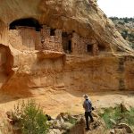
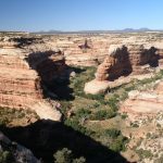
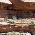
Map of Cedar Mesa
Cedar Mesa is home to the well-explored Grand Gulch as well as many other lesser-known canyons filled with Anasazi ruins, artifacts, and artwork. The area is basically a museum without the hours, fees, and glass cases. At least for now. Cedar Mesa could become part of a huge and heavily-contested proposed national monument in Southeast […]
-
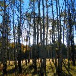
Abajo Mountains
The Abajo Mountains are visible from much of southeast Utah. They dominate the skyline of foothill towns like Monticello to the east and Blanding to the south. These remote mountains are filled with stunning scenery, like the conifers and quaking aspens of the valleys and north slopes. For the locals, they are a popular place […]
Featured Mountains in Monticello
| Mountain | Approx. Elevation |
|---|---|
| Twin Peaks | 11,012 ft (3,356 m) |
| South Peak | 11,122 ft (3,390 m) |
| Shay Mountain | 9,989 ft (3,045 m) |
| Horsehead Peak | 11,209 ft (3,417 m) |
| Abajo Peak | 11,360 ft (3,463 m) |
| Comb Ridge | 5,413 ft (1,650 m) |