Every “outdoor enthusiast” in the Seattle region knows about Mount Si. It’s considered a rite of passage in these parts. Everyone also knows that Mount Si is a hiker-only trail and that mountain bikes are seriously verboten. Besides, who would want to bike up that steep trail with all the roots, rocks, and hikers? Well, me for one. And I don’t think I’m alone. Real mountain bikers who ride UP trails in addition to down them see the value in at least attempting a challenge like Mount Si.
Years ago while I was in college, my friend Cliff and I poached the Mount Si Trail late one warm summer evening. The hikers descending in the last daylight hours were quite surprised to see us on the trail and I recall a few reminding us that mountain bikes were not allowed (like we didn’t already know). “Really?!?” we said, and kept riding up.
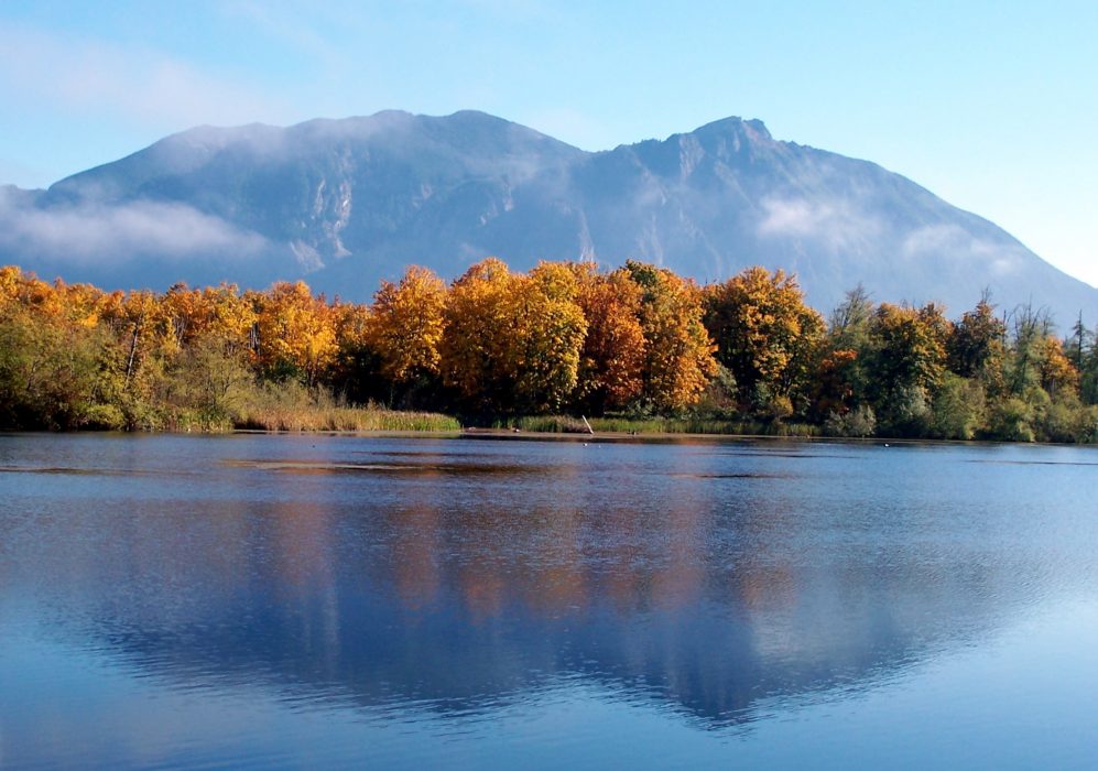 The Mt. Si massif from the west.
The ascent was as difficult as we’d expected, but fun nonetheless. On our handlebars we had mounted lights to complete our descent in the darkness. Cliff led the descent and I followed close behind. It was a moonless night; we couldn’t even see our hands in front of our faces. I remember one crash where my bike went flying into the woods and the impact turned off the headlight. It took me a while crawling around the brushy hillside to find my bike. Farther down, we encountered a guy sitting next to the trail in the dark. He had gone up to hang-glide but the conditions were bad so he walked down instead. Without a flashlight, he was stuck about halfway down. He said he would run down the trail behind us and that we didn’t need to go slow for him. His feet slapped loudly on the path as he tried to keep up and a couple times I heard him trip and go down hard, so I stopped to let him get ready to run again. Eventually, we all made it down safely and he thanked us profusely. We were proud of our accomplishment and we knew it would be our one and only ride on the trail. I am not writing this story to tell others to ride the Mount Si Trail. Honestly, I would not suggest it and the only reason I am sharing that story here is that I’m sure the statute of limitations on my crime has run out (and I am hoping that our hang-gliding buddy will read it so we can connect again and laugh about that night). I’m using this experience to share a discovery some other friends and I had more recently.
My buddy Dan had an idea one day: was it possible to circumnavigate the iconic peak using mountain bikes on a legal path? Well, after consulting maps and satellite images we found a couple of roads that climb up high on opposite sides of the ridge running north from Mount Si. Could they connect? We decided to do a recon trip in my truck to check the west side of the ridge first hand. We got close enough to the ridge to know it would be a short portage if the trails and roads on the other side went too.
After getting our biker gang together, we parked in North Bend and began the loop by heading east on the main drag and then following the Mt Si Road. At the end of that road, there is a forest service path called the CCC Road-Trail that takes off and follows the base of Mount Teneriffe and Green Mountain before teeing into Bessemer Mtn Road. The climb to the top of Bessemer Road ended at a boulder-strewn hillside that had been chewed up by something that resembled a mining operation. From there, we had to portage the bikes up and over the ridge crest. The boulders were big and loose; it wasn’t easy. On the other side, some snow lingered, which would have been fun boot-skiing, but we had bikes to carry and it took quite a while to navigate the slippery slope. All in, it was probably an hour-long frustrating portage.
There are three small lakes on the west side of the ridge and we rode to all of them before starting the long, continuous descent on dirt logging roads. The way down passes by Lake Hancock before crossing the North Fork Snoqualmie River and intersecting the main Weyerhaeuser Forest Road (NF-57), which leads north to many other peaks in the western front range. From that intersection, we simply rode south on the forest road to the paved roads that brought us back to town.
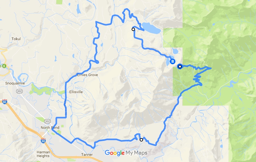 A Google Map showing the route
It was a fabulous ride that I’m sure few have ever done. In total it’s about 33 miles of riding plus significant elevation gain and the portage. If it wasn’t for that damn portage, this ride could be a rite of passage for local mountain bikers, much like the hiking trail is to everyone else.
Mountains on this map
| Mountain | Elevation |
|---|---|
| Mount Si | 4,075 ft (1,242 m) |
| Little Si | 1,532 ft (467 m) |
| Mount Teneriffe | 4,721 ft (1,439 m) |
| Green Mountain | 4,734 ft (1,443 m) |
| Bessemer Mountain | 5,052 ft (1,540 m) |