Having just visited Hawaii, I was curious about the island chain and all its volcanoes. I’ve read a few general things about the volcanoes in my travel guidebooks, but I wanted more details. Which ones are active? Is it possible to reach the summit on all of them? Which ones are accessible by car or by foot? Where is the next one and how far underwater is it? It’s confusing because there are volcano names, peak names, and vent names. Here is a rundown of what I found.
About the chain
The Hawaiian Islands are shield volcanoes, which simply means they are made by fluid lava flows and are broadly shaped, evoking the image of a shield facing the sky. Theories suggest that these are “hot spot” volcanoes created by a tectonic plate moving over a stationary hole where magma pushes up from the Earth’s mantle. This explains why the older volcanoes go dormant and eventually extinct in a fairly straight line along the Pacific Ocean floor. That must also mean that there is another volcano ready to take its place. More about that below. All of the volcanoes are extinct except for Haleakala and Mauna Kea which are considered dormant, and three volcanoes on the Big Island that are active (Hualalai, Mauna Loa, and Kilauea).
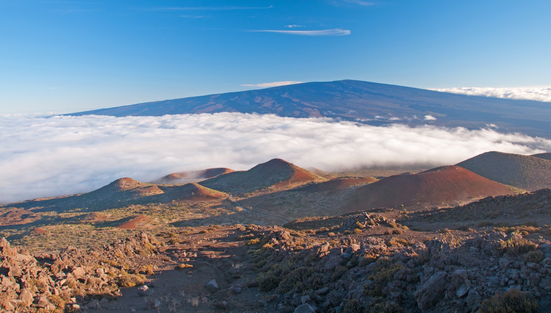 Mauna Loa looks like a shield from Mauna Kea
About the volcanoes
The Big Island
The island of Hawai’i, better known as “The Big Island,” is home to five volcanoes.
Kohala, a smaller volcano on the north end of the island is extinct. It is seldom climbed as it has no official trails and is choked with vegetation in places. That said, some have made it to the top.
Mauna Kea, a dormant volcano, is the highest of them all and one of the easiest to summit. All you need is a car and the ability to deal with the rapid altitude change from sea level to 13,803 feet (oh, and a coat – it’s cold up there).
The other three volcanoes, Mauna Loa, Hualalai, and Kilauea are active, however, the latter is the only one actively erupting. The volcanoes on all of the other Hawaiian Islands are considered extinct, with the exception of Haleakala on Maui which might just be dormant.
Hualalai, which last spouted in 1801, stands tall above the town of Kailua-Kona but is relatively short compared to neighboring Mauna Loa and Mauna Kea. The land around it is privately owned, but hikers still take a risk and hike the established old roads and trails to the peak.
Mauna Loa, which is also over 13,000 feet tall, last erupted in 1984 and could again at any time. It’s possible to day hike to the summit from the observatory on the north side of the summit at 11,000 feet, but it’s not easy at that elevation.
Kilauea is currently pouring molten lava out of the Pu’u ‘O’o Vent and has been erupting constantly since 1983. The Kilauea Crater doesn’t flow, but it can be visited via roads and trails in Hawai’i Volcanoes National Park on the south side of the Big Island.
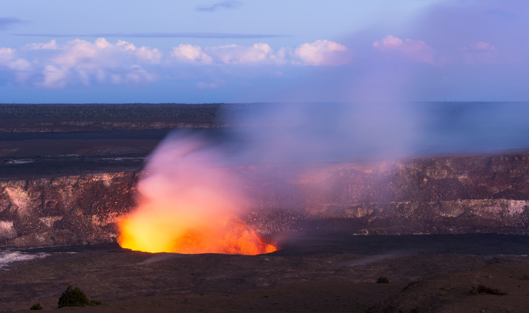 Kilauea Crater is still alive and glowing
Maui (including Lanai & Molokai)
Maui has six volcanoes spread across four separate adjacent islands. Maui proper has two, Haleakala which makes up the east side of the island, and Mauna Kahalawai which is better-known as the West Maui Mountains.
Haleakala is a popular volcano with a paved road to the summit where tourists can peer into the rust-colored valleys. Some tourists ride down the mountain road on rented bicycles. Note there is a little-known mountain bike route too! The summit of Haleakala is over 10,000 feet above the sea. At this point the volcano is considered “potentially active” but has not erupted since the 1600’s.
The summit of West Maui’s Mauna Kahalawai is Pu’u Kukui at 5,788 feet, but geologists suspect that it was over 13,000 feet high at one point. It’s amazing what a little erosion can do to an ancient volcano. It last erupted over 300,000 years ago and is considered extinct now. The summit is on private property and off-limits to the public.
Lanaihale is the volcano on the nearby island of Lanai. To reach the summit, simply hike the Monro Trail uphill from the trailhead at the Lanai Cemetery. Even though Larry Ellison owns the island now, it’s open to visitors who simply take a public ferry boat from the town of Lahaina on Maui.
Getting to the the island of Molokai, however, just got more difficult. The boat from Lahaina has been terminated so an expensive inter-island flight is your only option. If you can get there the island has two extinct volcanoes (but you’ll want to go for the beaches and the charm). Wailau is the east volcano. An old trail called the Wailau Trail can be used to ascend the Wailau Valley to the ridge crest, but it is overgrown and difficult to say the least. The true summit is probably accessible from the south side of the island where vegetation isn’t so thick.
Maunaloa is the western volcano on the island of Molokai near the town of Maunaloa, which isn’t much more than a tiny general store. Radio towers mark the summit from nearby Highway 460. The road from town to the towers (and a reservoir) is gated so it’s probably a closed facility. Lua Makika is the volcano on the dry uninhabited island of Kaho’olawe which was a military bombing range until 1990. You can’t go there.
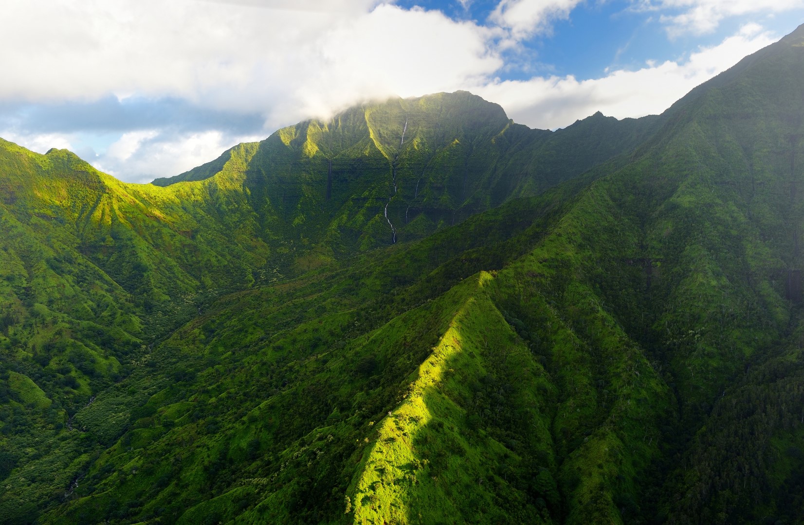
 Hiking trails high up inside Haleakala’s moon-like environment
Oahu
Oahu has eroded so much that the island’s two volcanoes are now just long jagged ridges, Ko’olau to the east and Wai’anae to the west. The Ko’olau Range has many peaks along its spine, which stretches from the eastern end of the island to the northern tip. Pu’u Konahuanui is the highest point and can be reached via a combination of trails that are reportedly muddy and challenging at times.
The Waianae Range is older but slightly higher. A broad, swampy plateau makes up the summit area of the highest point, Ka’ala. There is a road that leads to the summit where radio towers and a military facility can be found, but it’s closed to the public. A trail to the summit begins at the end of the Waianae Valley Road. It sounds seldom traveled, long, confusing, and even exposed at times (i.e. not for the average hiker).
Kauai
Kauai is made up of a couple volcanoes on two islands. Kauai itself has one large volcano that is estimated to be 5 million years old. Waialeale is the mountain of the Garden Isle. It’s windward slope is one of the wettest places on the planet averaging over 450 inches of rain annually. Seeing the summit isn’t easy from what I’ve read. There is no trail so you’ll need navigational skills and determination. I simply used a helicopter and got lucky to have clear weather.
The second Kauai volcano is on the small adjacent island of Ni’ihau which is privately owned and off-limits to the general public. Paniau is the high point of the Ni’ihau volcano which is a fraction of its former self due to a large landslide long ago.
 The rain soaked slopes of Waialeale on Kauai
Northwestern Islands
I thought that Ni’ihau was the westernmost volcano in the range that still pokes out of the water. Turns out I was wrong. There are ten more remnants of older volcanoes that form reefs, atolls, or islets west off the main islands. They are known as the Northwestern Hawaiian Islands and are now protected as part of Papahānaumokuākea Marine National Monument. These remote tiny islets are mostly visited by scientists that have permitted authorizations. From east to west, the islands are as follows (Hawaiian name in parentheses):
- Nihoa Island (Moku Manu), 23.06067, -161.92108
- Necker Island (Mokumanamana), 23.57492, -164.70041
- French Frigate Shoals (Lalo), 23.78695, -166.21083
- Gardner Pinnacles (‘Onunui & ‘Onuiki), 24.99892, -167.99896
- Maro Reef (Kamokuokamohoali’i), 25.43791, -170.58996
- Laysan Island (Kamole), 25.76994, -171.73233
- Lisianski Island (Kapou), 26.06387, -173.96561
- Pearl & Hermes Atoll (Manawai), 27.78972, -175.81765
- Midway Islands / Atoll (Kuaihelani), 28.21046, -177.37072
- Kure Atoll (Holaniku), 28.39192, -178.29617
New islands coming soon
Well, relatively soon in plate tectonic time. The Lo’ihi Seamount, just off the southern shore of the Big Island and not far from Kilauea, is next in line. The summit is about 3,000 feet below sea level, but it already resembles a volcano with a crater three miles wide. You can actually see its shape in Google Earth using the coordinates 18.91713, -155.25939.
Mountains on this map
| Mountain | Elevation |
|---|---|
| Mauna Kea (State High Point) | 13,803 ft (4,207 m) |
| Mauna Loa | 13,679 ft (4,169 m) |
| Kilauea Volcano | 3,668 ft (1,118 m) |
| Hualalai | 8,261 ft (2,518 m) |
| Kohala | 5,072 ft (1,546 m) |
| Haleakala | 8,209 ft (2,502 m) |
| Mauna Kahalawai | 5,788 ft (1,764 m) |
| Lanaihale | 3,370 ft (1,027 m) |
| Wailau | 4,961 ft (1,512 m) |
| Maunaloa | 1,381 ft (421 m) |
| Lua Makika | 1,483 ft (452 m) |
| Ko’olau Range | 3,150 ft (960 m) |
| Wai’anae Range | 4,025 ft (1,227 m) |
| Waialeale | 5,243 ft (1,598 m) |
| Paniau | 1,289 ft (393 m) |