There is a reason why the Ansel Adams photographs of the Snake River and the Tetons have become some of his most recognizable works. The dramatic contrast between the flat river valley and the steep peaks is stunning. Grand Teton stands erect at 13,770 feet and Jenny Lake, at its base, sits at 6,783 feet. This full relief is visible from the east and creates one of the most photogenic mountain ranges in the US. Climbers from all over the world set their sights on the Grand as it has become one of the best-known American peaks. The easiest route is still rated at a class 5.4 grade II, requiring rock climbing skills and serious preparation. It’s often climbed with a guide service. A few years ago a friend and I were able to climb Middle Teton sans problems or guides. Looking up at the Grand from the summit put our climb in perspective.
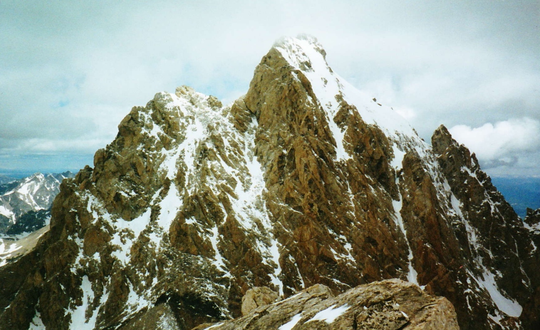 The Grand still seems huge from Middle Teton
Above is a map of the Tetons and below is a comprehensive list of the peaks in the range. Almost all of the peaks are inside Grand Teton National Park. To hike or backpack here, you’ll have to pay a fee to enter the park, but you already knew that. The park road is closed in the winter, making winter recreation difficult as well. The Jackson Hole Ski Resort is on the eastern face of Rendezvous Mountain giving you one easy option however. Grand Targhee Resort is another option especially for those coming from the Idaho side of the range.
Access to the popular trailheads on the eastern side of the Tetons is easiest from the south starting in Jackson. Head north on the highway to Moos Junction and turn left into the park. Note that all visitor facilities are shuttered and roads in the park are closed to motor vehicles during the winter months.
 South, Middle, Grand, Owen, and Teewinot (Mt. St. John in distance far right)
For photographing the range it’s best to drive roads on the eastern side of the Snake River Valley. The forest road that ascends Shadow Mountain has worked well for me before. That mountain is shown on the map above in red. There are several good photo ops along the highway and down by the river. Those are your only options when east valley backroads are snow-covered.
A map with the park entrance stations, trailhead locations, and hiking trails is available from the National Park Service. Topographic maps are linked from every mountain page shown on our map above. Here is a direct link to topos of Grand Teton National Park.
Mountains on this map
| Mountain | Elevation |
|---|---|
| Grand Teton | 13,770 ft (4,197 m) |
| Middle Teton | 12,804 ft (3,903 m) |
| South Teton | 12,514 ft (3,814 m) |
| Teewinot Mountain | 12,325 ft (3,757 m) |
| Mount Owen | 12,928 ft (3,940 m) |
| Mount Moran | 12,605 ft (3,842 m) |
| Buck Mountain | 11,938 ft (3,639 m) |
| Mount Wister | 11,490 ft (3,502 m) |
| Static Peak | 11,303 ft (3,445 m) |
| Cloudveil Dome | 12,026 ft (3,666 m) |
| Prospectors Mountain | 11,241 ft (3,426 m) |
| Mount Hunt | 10,783 ft (3,287 m) |
| Thor Peak | 12,028 ft (3,666 m) |
| Nez Perce | 11,901 ft (3,627 m) |
| Mount Saint John | 11,430 ft (3,484 m) |
| Rockchuck Peak | 11,144 ft (3,397 m) |
| Mount Woodring | 11,590 ft (3,533 m) |
| Doane Peak | 11,355 ft (3,461 m) |
| Bivouac Peak | 10,825 ft (3,299 m) |
| Eagles Rest Peak | 11,258 ft (3,431 m) |
| Traverse Peak | 11,051 ft (3,368 m) |
| Ranger Peak | 11,355 ft (3,461 m) |
| Rendezvous Peak | 10,927 ft (3,331 m) |
| Mount Glory | 10,086 ft (3,074 m) |
| Disappointment Peak | 11,618 ft (3,541 m) |
| Taylor Mountain | 10,352 ft (3,155 m) |
| Survey Peak | 9,277 ft (2,828 m) |
| Moose Mountain | 10,054 ft (3,064 m) |
| Housetop Mountain | 10,537 ft (3,212 m) |
| Spearhead Peak | 10,131 ft (3,088 m) |
| Fossil Mountain | 10,915 ft (3,327 m) |
| Mount Bannon | 10,966 ft (3,342 m) |
| Mount Meek | 10,681 ft (3,256 m) |
| Mount Jedediah Smith | 10,610 ft (3,234 m) |
| The Wedge | 10,357 ft (3,157 m) |
| Albright Peak | 10,552 ft (3,216 m) |
| Veiled Peak | 11,306 ft (3,446 m) |
| Treasure Mountain | 9,841 ft (3,000 m) |
| Battleship Mountain | 10,679 ft (3,255 m) |
| Shadow Peak | 10,725 ft (3,269 m) |
| The Jaw | 11,400 ft (3,475 m) |
| The Wigwams | 10,855 ft (3,309 m) |
| Freds Mountain | 9,880 ft (3,011 m) |
| Littles Peak | 10,712 ft (3,265 m) |
| Beard Mountain | 9,466 ft (2,885 m) |
| Maidenform Peak | 11,137 ft (3,395 m) |
| Cleaver Peak | 11,055 ft (3,370 m) |
| Window Peak | 10,508 ft (3,203 m) |
| Green Lakes Mountain | 10,195 ft (3,107 m) |
| Crows Nest | 9,721 ft (2,963 m) |
| Raynolds Peak | 10,910 ft (3,325 m) |
| Dry Ridge Mountain | 10,321 ft (3,146 m) |
| Rolling Thunder Mountain | 10,908 ft (3,325 m) |
| Rammell Mountain | 10,140 ft (3,091 m) |
| Mount Nord | 9,725 ft (2,964 m) |
| Red Mountain | 10,177 ft (3,102 m) |
| Owl Peak | 10,612 ft (3,235 m) |
| Elk Mountain | 10,712 ft (3,265 m) |
| Forellen Peak | 9,772 ft (2,979 m) |
| Hominy Peak | 8,362 ft (2,549 m) |
| Mount Berry | 8,971 ft (2,734 m) |
| Green Mountain | 9,614 ft (2,930 m) |
| Table Mountain | 11,106 ft (3,385 m) |
Landmarks on this map
| Shadow Mountain Viewpoint |
| Jackson Hole Resort See details |
| Grand Targhee Resort See details |
| Moose Junction Park Entrance |
| Jackson, Wyoming See details |