I’ve never been to Gamma Hot Springs, but I heard about this remote soaking pool anytime the conversation steered towards hot springs around Seattle. Apparently, I’m not alone either – most folks know of someone who has been there, but the “knowing” feels more like playing six degrees of Kevin Bacon rather than scrolling through their phonebook.
 Glacier Peak from Image Lake above the Suiattle River. Gamma Peak is below and slightly left of Glacier Peak Summit. Gamma Hot Springs is in the valley below Gamma Peak.
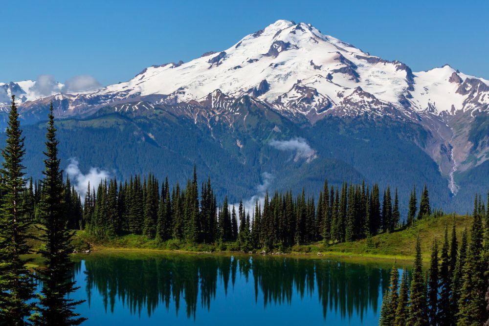
From what I’ve heard, Gamma’s soaking pool is rather small and close to the creek, which allows a nice way to regulate the temperature of the 140F spring. If you go, you will definitely be the only people there and there is a black plastic tube near the spring containing notes from previous visitors and a guest log. Numerous trials have been washed out over the years and the final mile to the spring is classic North Cascades bushwhacking. Gamma is hot, remote, and a challenge; I’m in.
So, I placed my query with Google and got the usual – rave reviews, not-so-rave reviews, and conflicting directions on message boards; a topographic map with the approximate location but no trail or access information; and a few grainy images and videos. Thinking that hot springs would be something the USGS catalogs, I searched and found NOAA’s Thermal Springs of the US map – an awesome tool for temperatures and rough GPS coordinates for springs and thermal vents around the US.
NOAA’s information on Gamma:
Temperature (F): 140 (at the source)
Temperature (C): 60 (at the source)
Temperature Category: Hot
Coordinates: 48.15, -121.062 (not quite accurate)
NOAA’s coordinates seemed rough, with latitude degrees only going out to the hundredth decimal place, so I matched them up with Google’s known coordinates and, with a little satellite assistance, found my best guess as to the location of the spring. But, I still didn’t have reliable directions to the rugged location, at least 12 miles from the nearest road and close to the summit of Gamma Peak. After combing a few forum threads, I eventually found a few comments about “the most complete” directions offered to the spring. Dead link. So, I went into the Wayback Machine (a tool provided by the Internet Archive that allows you to time travel on the web) and found a six-year-old version of the page, directions intact.
The easiest approach is to drive to the end of Suiattle River Road (near Darrington, WA). Hop on the Suiattle River Trail (784) and hike 11 miles to the intersection with the PCT (2000). Turn right at the junction to head south and when you reach the Upper Suiattle River Trail (798), take a left. Within the first tenth of a mile, look for the sign to Gamma Ridge Way to the right and head towards Gamma Peak. The following unedited instructions seemed to be the most complete (for a summer trip), based on message boards and forums, and we verified the trail intersections and names on Topozone.com.
First mile of the trail is overgrown with bushes and has quite a few blow-downs. After that trail turns into switchbacks and climbs steeply through the woods, where it is not as overgrown, but still has blow-downs. In about 3 miles it enters the first meadow. There is a campsite there.
Following the ridge the trail continues further going through woods and meadows. It is very easy to lose the trail in the grass. Continue to go straight, ascending to the ridge. In about 2 miles there will be a very nice place for a campsite – an open, even meadow on the top of the hill with an impressive view.
From this point, climbing equipment and skills are needed.
For some time trail follows the ridge to Gamma Peak. Cross the first gully after the campsite and continue further. The slope is very steep and covered with snow. If you do not have ice-axe, your best way to cross the gully is to follow the top of the ridge. It is about 0.5 miles between the campsite and the turn to Gamma Hot Springs. To get to the summit you need to cross the last gully and start climbing up the trail.
If your destination is Gamma Hot Springs do not cross the last gully and do not go up to the summit, but instead turn right and follow the ridge down. One should not make an attempt to follow creeks drainage, this can be very dangerous. Make sure you look for a trail going somewhat in the middle between Gamma Creek and its right tributary. Due to the snow, you will not be able to see the trail right away, but look for it on your way down. It quickly descends following the ridge.
In about 1.5 miles you will reach the area where Gamma Creek meets with its tributary. At this point, if you will continue straight you will reach a very steep downhill, instead what you need is to go down the right slope to the tributary. Cross tributary and continue down Gamma Creek for another 0.3 mile. It is very hard to see the trail on the rocky slope, so pay attention. Also, it is very important that you do not go down to the creek immediately after crossing the tributary, but continue about 10 – 20 feet up on the bank. You will begin to scent the springs.
The pool is not very big and situated on the open slope very close to the creek. This allows you to control the temperature of the water, for it is quite high – about 150F. Right near the pool there is a piece of black pipe, which contains notes of those who visited the springs. Left of the creek across the pool there is a campsite big enough for one tent, but about 300 feet downhill there is another spot that is possible to use for camping. It will take you about another hour and a half to reach the hot springs.
Apparently, if you want to avoid the bushwhacking, a winter ski tour is also an option. With the adventure Gamma Hot Springs offers up, this storied soaking hole might quickly lose its spot on the Places I’ve Never Been list.
Please Note: As stated above, I have actually never been to Gamma Hot Springs. Although all the information, coordinates, and beta provided is based on thorough research, it is by no means a complete guide and should be supplemented with your own research about Gamma and its heated waters. If you have firsthand experience with potential hazards or find any of this information completely wrong please let us know.
Mountains on this map
| Mountain | Elevation |
|---|---|
| Gamma Peak | 6,916 ft (2,108 m) |
Landmarks on this map
| Trailhead/parking area for Suiattle River Trail (784) |
| Intersection of Trail 784 and PCT |
| Gamma Hot Springs See details |