The Ptarmigan Traverse is a high elevation route in the North Cascade Range of Washington State. It was first done in 1938 by a group from the Ptarmigan Climbing Club and didn’t become popular with mountaineers until much later. Nowadays, many groups tackle the traverse every summer.
For experienced mountaineers, this trip has a lot to offer – it’s a mixed route of rock and glacier travel with navigational challenges. Experience is key because this zone is rugged, remote, and unforgiving. There are many peaks to photograph or climb along the traverse as well. For those who are intent on climbing all the mountains on the Bulger List, this traverse is spectacular. Several peaks along the route are among the highest 100 in Washington. Of course it would take more time to climb out to these peaks from the traverse route, but it would also yield a much bigger accomplishment. The Bulgers Sahale and Buckner are near the north end, and Dome and Sinister are near the south end.
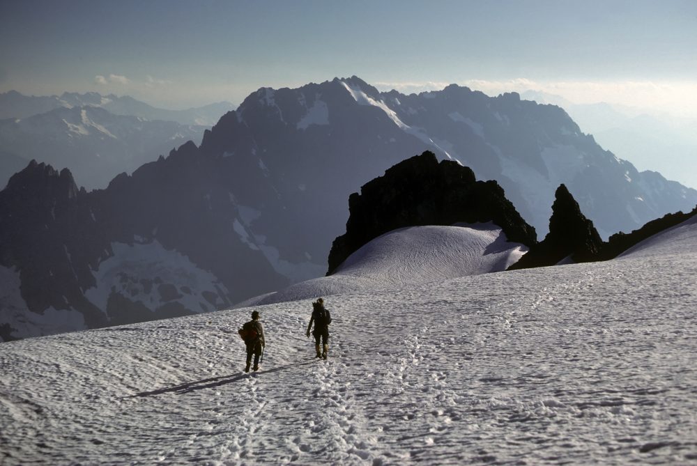 Descending from Sahale Peak toward the north trailhead
Most climbers do the traverse north to south, mainly because the north trailhead starts at higher elevation and has a shorter approach. The north trailhead is at the end of the Cascade River Road which begins near Marblemount. The south trailhead is at the end of the Suiattle River Road which leaves the main highway between Darrington and Rockport.
Logistics:
The route is partially in North Cascades National Park so backcountry permits are required.
Both access roads leading to the north and south trailheads have been damaged in recent years forcing cars to be parked farther from the trailheads. Be sure to check road conditions with Mt. Baker-Snoqualmie National Forest and the National Park Service before heading out.
The trip can be anywhere from five days to two weeks depending on your goals. Some folks have done it much faster, but that would take the fun out of it.
The season is July through early September and during a reliable weather forecast. Still plan on potential wet and windy weather up here as it is common regardless of what’s going on down below.
Cell phones don’t work on the traverse so consider a satellite phone or at least a Spot-like satellite emergency device.
Our map above shows all of the mountains along the route and the trailheads. We suggest that you print topographic maps of the route (each of our mountain pages link to a topo map). SummitPost has the most complete description of the actual route.
Mountains on this map
| Mountain | Elevation |
|---|---|
| Buckner Mountain | 9,112 ft (2,777 m) |
| Sahale Mountain | 8,680 ft (2,646 m) |
| Mix-up Peak | 7,231 ft (2,204 m) |
| Magic Mountain | 7,536 ft (2,297 m) |
| Hurry-up Peak | 7,812 ft (2,381 m) |
| Arts Knoll | 7,172 ft (2,186 m) |
| Mount Formidable | 8,325 ft (2,537 m) |
| Spider Mountain | 8,238 ft (2,511 m) |
| Le Conte Mountain | 7,739 ft (2,359 m) |
| Sentinel Peak | 8,205 ft (2,501 m) |
| Old Guard Peak | 8,051 ft (2,454 m) |
| Lizard Mountain | 7,306 ft (2,227 m) |
| German Helmet Peak | 7,510 ft (2,289 m) |
| Spire Point | 8,146 ft (2,483 m) |
| Dome Peak | 8,920 ft (2,719 m) |
| Sinister Peak | 8,440 ft (2,573 m) |
Landmarks on this map
| North Trailhead The north trailhead for the Ptarmigan Traverse is at the end of Cascade River Road (FR 15) which has been damaged recently 3 miles from the trailhead. See details |
| Cascade Pass Cascade Pass is at about 5400 feet elevation and divides the drainages for the Cascade River and Stehekin River. See details |
| Bachelor Creek Trail This boot-beaten path is the connector between the maintained trail at Downey Creek and the high elevations at the southern end of the traverse. See details |
| Downey Creek Trail Intersection Turn left if going south and turn right if going north. See details |
| South Trailhead The south trailhead for the Ptarmigan Traverse is at the end of Suiattle River Road (FR-26). See details |