
Atlas and Gazetter: Minnesota
Maps!
Atlas and Gazetter:
Minnesota
 Go to Park Details
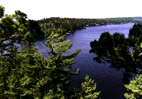
The park lies in the southern part of the Canadian Shield, representing some of the oldest exposed rock formations in the world. This bedrock has been shaped and carved by at least four periods of glaciation. In the years since the last period of glaciation, a thin layer of soil has been created which supports the boreal forest ecosystem, the "North Woods," of Voyageurs National Park.
Voyageurs is a land rich in human history. The park's waterways were an important stretch of the "voyageurs' highway" from the Great Lakes into the interior of the western United States and Canada. Voyageurs National Park was named for the French-Canadian canoemen who traveled these waters in their birch-bark canoes. The days of the voyageurs are long gone, but the waters they traveled remain and continue to influence and be influenced by humans. It is these waters and the accompanying scenery, geology and rich cultural and natural resources that give Voyageurs its national significance, significance that grants its protection for the enjoyment of present and future generations.
The park was established on April 8, 1975 by then-President Richard Nixon. Speaking about the park, he said, "The uniquely scenic and historic Voyageurs National Park, 36th in our National Park System, stands as a monument forever to the dedicated citizens and conservation organizations whose vision, ingenuity and courage matched the splendor of this superlative wilderness area.
Rich in the history of the early, exciting exploration of our great country, Voyageurs will serve as a living legacy linking generation to generation and century to century."
Park Details
![]()
Location Information
Located on the northern border of Minnesota, 55 miles of the park stretch along the Ontario border. Voyageurs is about 15 miles east of International Falls, MN and 300 miles north of Minneapolis-St. Paul, MN. The Boundary Waters Canoe Area Wilderness lies to the east of the park.
Address:
Voyageurs National Park
3131 Highway 53
International Falls, MN 56649-8904
Telephone:
Headquarters (218) 283-9821
FAX (218) 285-7407
Acreage:
Total: 218,054.79
Land - 134,265.79
Water - 83,789.00
![]()
Operating Hours/Seasons
The park is open year round.
Visitor Center Hours:
Rainy Lake Visitor Center
Telephone: (218) 286-5258
Fax : (218-286-5250
Daily, 9 a.m. - 5 p.m.
May 8 - September 30.
(Inquire about winter hours.)
Kabetogama Lake Visitor Center
Telephone: (218) 875-2111
Fax: (218) 875-2114
Daily, 9 a.m. - 5 p.m.
May 8 - September 30.
Ash River Visitor Center
Telephone: (218) 374-3221
Daily, 9 a.m. - 5 p.m.
May 23 - September 2.
Crane Lake Information Station
Telephone: (218) 993-2481
Daily,10 a.m. - 4 p.m.
May 23 - September 2.
![]()
Climate, Recommended Clothing
The park has a cool continental climate with short warm summers followed by long winters. Average summer highs range from 60 degrees F to 80 degrees F; winter highs range from 10 degrees F to 30 degrees F. The boating and canoeing season begins as early as the end of April and lasts until freeze-up sometime in November. The winter snowmobile and ski season generally begins in late December. Annual precipitation averages 28 inches.
![]()
Facilities and Opportunities
Visitor Center/Exhibits:
Regular showings of a short park film and interpretive exhibits at the visitor centers provide an
excellent overview of the park's natural and cultural resources. Information on camping and other
park recreational uses is also available. Lakes States Interpretive Association has maps, books,
tapes, and other interpretive items for sale at each of the visitor centers.
Trails/Roads:
The Cruiser Lake Trail (9 miles) and the Locator Lake Trail (2 miles) offer hiking and camping
opportunities on the Kabetogama Peninsula. Both trails provide access to interior lakes, where
watercraft are available for visitor use through reservations made at the Ash River, Kabetogama Lake
or Rainy Lake Visitor Center.
For day hikes, the Blind Ash Bay Trail (2 miles) provides beautiful vistas of Kabetogama Lake. This trail is accessible from the Ash River Visitor Center. On Rainy Lake, the Oberholtzer Interpretive trail is accessible from the Rainy Lake Visitor Center, and the Little American Island Gold Mine Trail is accessible from the waters of Rainy Lake.
Additional information on these trails can be obtained at any of the visitor centers.
Snowmobile Trails:
Over 110 miles of snowmobile trails cross the frozen surfaces of the principal lakes. These trails
have portages around areas of unstable ice and connect with trails outside the park. In addition to
these trails, the minimally-maintained Chain of Lakes Snowmobile Trail twists and turns through the
back country of the Kabetogama Peninsula.
Cross-Country Ski Trails:
Ten miles of groomed cross-country ski trails are accessible from near the Rainy Lake Visitor Center.
Twice each winter, join a park naturalist for a candle-light ski followed by a cup of hot cider. This
past winter, the Echo Bay Hiking and Ski Trail near Kabetogama Lake was opened for public use
for the first time.
Fishing and Boating:
Boating and fishing are the most common recreational uses of the park. Known as some of the best
walleye water in the nation, the lakes have attracted sport fisherman long before the park was
established. A Minnesota fishing license is required.
Canoeing and Kayaking:
Even though waters are shared with powerboats, the lakes of Voyageurs National Park are large
enough to provide for some solitude. A range of canoe and kayak trips are available, from day-trips
to journeys lasting over a week; the Kabetogama Peninsula can be circumnativgated in approximately
one week. Inquire at the visitor centers for recommended routes.
Boats on Interior Lakes:
Voyageurs provides, free of charge, watercraft on the following interior lakes of the Kabetogama
Peninsula: Locator, Quill, Ek, Cruiser, Little Shoepack and Shoepack. Boats are available on a
first-come, first-served basis. Reservations to use these boats can be made one week in advance
at the visitor centers. The trails leading to these interior lake boats are accessible only by water;
water taxi service can be arranged for visitors without transportation to these trail heads.
Watercraft Rental:
Many of the resorts and lodging facilities in the four gateway communities offer watercraft rental,
water taxi service and guide services. Three resorts in the Crane Lake community offer concession
boat rentals on Mukooda Lake. Houseboat rental is available at Ash River, Crane Lake and
International Falls.
Programs/Activities:
During the summer season, naturalists offer interpretive walks, evening programs, children's activities,
canoe trips, a junior ranger program and North Canoe Voyages. Schedules of these activities and
their locations are available at each of the visitor centers.
Lodging and Camping Facilities:
There are over 150 boat-in campsites distributed throughout the park designed for either tent
camping or houseboats. Designated tent sites have a mooring post, tent pad or level area, fire
ring, privy, picnic table and bear-proof food-storage locker. Houseboat sites include two mooring
posts and a fire ring. In addition to the designated sites, there are approximately 400
traditionally-used sites available to campers. There are currently no fees, permits, or reservation
requirements; camping is on a first-come, first-served basis.
The historic Kettle Falls Hotel offers lodging within the park. Often called the "Jewel in the Wilderness," Kettle Falls is accessible by boat, floatplane, and snowmobile. It is a concession-operated complex that includes a dining room, bar and rooms in the historic 1912 motel and modern housekeeping villas. Kettle Falls offers a portage between Rainy Lake and Namakan Lake; gasoline can also be purchased.
The gateway communities of Ash River, Crane Lake, International Falls and Kabetogama Lake offer a range of facilities including motels, cabins, Bed and Breakfast Inns and campgrounds.
The Minnesota Department of Natural Resources operates the Woodenfrog State Forest Campground on Lake Kabetogama and the Ash River Campground on Ash River.
Boat Tours:
Boat tours are provided by concessioner on Rainy Lake's "The Pride of Rainy Lake"
and Lake Kabetogama's "The Sight-Sea-Er." Trips offered include sunset cruises, wildlife-watching cruises
and cruises to the historic Kettle Falls Hotel; most trips are naturalist-guided. Reservations are
suggested; check with the Kabetogama or Rainy Lake Visitor Centers for more details.
Education:
Educational programs are given by park naturalists at area schools throughout the year. Or schools
may choose an in-park educational experience, which includes a trip on the concession-operated
tour boat "The Pride of Rainy Lake" and a hike into a beaver pond. Reservations are required and
can be made by calling the Rainy Lake Visitor Center.
Accessibility:
The Kabetogama Lake and Rainy Lake Visitor Center and the concession-operated tour boats are
accessible. The main floor of the Kettle Falls Hotel and the trails, docks and villas at Kettle Falls
are all accessible. The first half of the Oberholtzer trail at the Rainy Lake Visitor Center and the
Beaver Pond Trail near the Ash River Visitor Center are fully accessible. The Ash River Visitor
Center underwent restoration work in 1997 that included improvements in accessibility.
Food/Supplies:
There are restaurants and grocery stores on the periphery of the park.
![]()
Visitation
Park visitation is highest from May through August when boating, camping, fishing, wildlife-watching and hiking are the main visitor activities. In the fall, canoeists and kayakers can experience the beautiful colors of Voyageurs during a season with less visitors and few insects. From January through March, the park is a primary destination for winter snowmobile vacations.
Hazards:
Weather conditions can be extremely variable both in summer and winter. Due to the often harsh
cold of winter and the variable temperatures of summer, layers of clothing are recommended.
Storms can rise quickly, and travel on large lakes can be dangerous. Current lake conditions
and additional weather information can be obtained at the visitor centers.
Voyageurs has a U.S. Coast Guard numbered buoy system to guide boaters. This system is dependent on the direction of water flow and can be explained by park staff in the visitor centers. Hazardous rocks, reefs and sandbars appear and disappear during the course of yearly water fluctuations. Not all hazards are marked. Boaters unfamiliar with the park should equip themselves with a map and compass and discuss travel routes with a ranger before leaving.
To prevent illnesses, lake water must be treated by boiling, filtering or chemicals before drinking.
Biting insects can interfere with the enjoyment of some summer activities. Dress appropriately and carry desired repellant.
Voyageurs is black bear country. Bear-proof methods of food storage is required. Be prepared to hang your food if food-storage locker space is not available. More information on precautionary measures regarding bears can be obtained at the visitor centers.
![]()
Special Events Programs
Ice Box Days: January
Kabetogama's Lady Slipper Festival: late June
Crane Lake Voyager Days: mid-July
Orr Heritage Days: late July
Artist in the Park: early August
National Park Day: late August
![]()
Adjacent Visitor Attractions
Boise Cascade of International Falls:
Mill tours are offered June through August without
reservations. Children under ten are not allowed on the tour. Forest Tours begin June 12 and are
offered every other Wednesday throughout the summer. This field trip includes lunch; reservations
can be made at (218) 285- 5217.
Boundary Waters Canoe Area Wilderness and Superior National Forest:
Crane Lake is the
western most entry point for the BWCAW; use requires permits from the Forest Service. The
Superior National Forest offers trails, picnic grounds and campgrounds. The Vermilion Gorge Trail
and the Vermilion Falls Trail near Crane Lake access spectacular geologic features.
Grand Mound History Center:
Operated by the Minnesota Historical Center, the Grand Mound
History Center is located 17 miles west of International Falls on State Highway 11. The center is
open May 1 through September 1 daily and September through April on weekends. Admission is
charged.
International Border:
From International Falls, drive or walk across a toll bridge to Fort
Frances, Ontario. Or depart from Crane Lake and travel by boat to the Canadian Trading Post
on Sand Point Lake. Visitors are required to check in with Canadian Customs.
Koochiching County Historical Museum and Bronco Nagurski Museum:
This complex is
located in Smokey Bear Park, International Falls and is open from Memorial Day through Labor
Day. Admission is charged.
![]()
Additional Information
Voyageurs National Park
3131 Highway 53
International Falls, MN 56649-8904
Ash River Commercial Club (800) 950-2051
Crane Lake Visitor & Convention Bureau (800) 326-7405
International Falls Area Visitors & Convention Bureau (800) 325-5766
Kabetogama Lake Association (800) 524-9085
Navigational charts and topographic maps may be purchased at the visitor centers or by mail from the Lake States Interpretive Association (218) 283-2103.
Recommended Reading:
Voyageurs National Park, Greg Breining;
Voyageurs National Park Water Routes, Foot Paths
and Ski Trails, Jim DuFresne.