Death Valley Backcountry Hikes
Go to Map
Go to Hikes
Check with a park ranger at the Visitor Center or at a Ranger Station before departing on the following trips. A backcountry registration form is not required, but is highly recommended for those hiking alone. At the very least, let someone know where you are going and your estimated time of return.
In temperatures over 90 F, hiking can be especially hazardous. During hot spring, summer or fall months one gallon of water per person per day is the minimum you should carry. Many of the springs in Death Valley are either dry or have been contaminated by burros, so do not rely on them. Do not camp in drainages or washes. Camp at least two miles from a maintained road and 200 yards from water sources.
Only Telescope & Wildrose Peaks have maintained hiking trails. These are the only hikes recommended in summer due to the extreme heat at lower elevations. The rest of the suggested overnight hikes are cross-country routes. Mileages can be deceiving, so allow plenty of time for these trips. Purchase topographic maps at the Visitor Center.
Top of Page

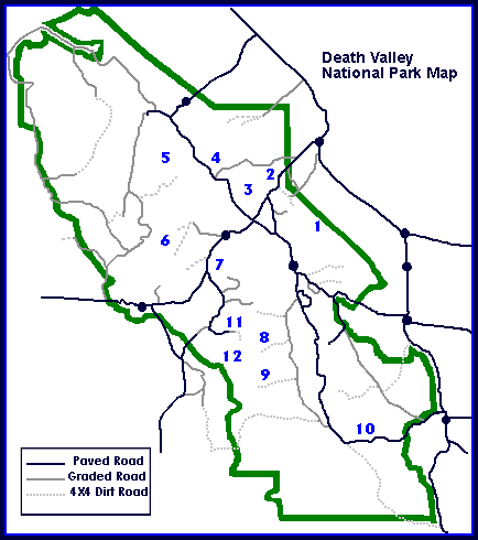
Hikes (See Map Above for Location)
1) Indian Pass
- Moderately strenuous with an elevation gain of 3,000 feet.
- Start 6.5 miles north of the Furnace Creek Visitor Center (near mile marker 104). Follow the wash bearing left (north) staying in the drainage nearest the ridge and heading for the low pass in the mountains. It is 8 miles one way. Climbing to the top of the pass is difficult and extremely steep.
- Springs and bighorn sheep may be seen in the four mile stretch of canyon.
- No camping at springs.
- 7.5 minute topo Nevares Peak.
2) Daylight Pass to Titus Canyon Road
- Moderately strenuous with an elevation change of 400 feet.
- Hike northwest from Daylight Pass 4.5 miles to Titus Canyon road. Two desert springs along route. Route finding may be difficult so a detailed map is advised.
- No camping at springs.
- 7.5 minute topo Daylight Pass.
3) Titanothere Canyon
- Moderately strenuous with an elevation change of 4,700 feet.
- Start 11 miles down the Titus Canyon Road. There are 2 forks of this wide canyon, just make sure you park so that you are not blocking the road. Hike down the wash 12 miles to the Scotty's Castle Road. There are springs, fascinating geologic formations and spectacular views of Death Valley. It helps if you have a 2 car shuttle system so you can walk down the canyon. If not, an option is to walk 4.5 miles to Lost Man Spring and return the same way.
- No camping at springs.
- 7.5 minute topo Thimble Peak.
4) Fall Canyon
- Moderate with an elevation gain of 1400 feet.
- Start at Titus Canyon parking lot (west side of canyon). Walk 0.5 mile north to a large wash. Wash leads into canyon with high, narrow walls, similar to Titus. Two and a half miles in, you dead end at a dry waterfall which requires climbing skills to pass on the south side. Beyond this point the way is open for another four or five miles.
- Narrow canyons and bighorn sheep.
- 7.5 minute topo Fall Canyon.
5) Bighorn Gorge
- Strenuous with an elevation change of 5,000 feet.
- From White Top Mountain it is 8 miles to Mesquite Springs Campground with 5 miles of it through the gorge. There is an eighty-foot dry fall in Bighorn Gorge, so scrambling around it on the north side of the fall is required.
- Bighorn sheep and remote wilderness.
- 7.5 minute topos Tin Mountain and White Top Mountain.
6) Cottonwood to Marble Canyon Loop
- Strenuous with an elevation gain of 3,000 feet.
- Begin this 26 mile loop at the end of the Cottonwood Canyon road, 4x4 high clearance. Follow the Cottonwood drainage up for six miles then hike northeast, crossing Deadhorse Canyon and bearing northwest into Marble Canyon. No trail past upper Cottonwood Spring. Follow Marble Canyon down for 8.5 miles to the junction with Cottonwood Canyon, and then up another 8.5 miles to your starting point.
- Narrow canyons, bighorn sheep, and wilderness backcountry.
- No camping at water sources.
- Flash flood danger.
- 7. 5 minute topos East of Sand Flat, Cottonwood Canyon, and Harris Hill.
7) Jayhawker Canyon
- Moderate with an elevation gain of 2600 feet.
- Start at 3000 feet elevation sign on Highway 190, 2.3 miles past Emigrant Junction. Walk the 1850 route of '49er pioneers. Some of them signed their names on a large boulder two miles in. Five miles one way, gentle grade to base of Pinto Peak.
- 7.5 minute topo Emigrant Canyon.
8) Hanaupah Canyon
- Moderately strenuous with an elevation gain of 2200 feet
- From West Side Road drive 5 miles up Hanaupah Canyon (high clearance) and park before road drops into wash. From here the road becomes 4 WD and continues another 4.5 miles up the south fork. Walk or drive up the road 1.5 miles to where the canyon splits. From here one can hike at least 3 miles up the middle fork, or continue up the south fork another 3 miles to road's end and another 1.5 miles (climbs steeply) on closed roads.
- Springs, forests, and mountain views.
- 7.5 minute topo Telescope Peak and Hanaupah Canyon.
9) Hungry Bill's Ranch
- Moderately strenuous with an elevation gain of 1100 feet.
- From West Side Road drive 10.5 miles up Johnson Canyon (4x4 high clearance) to road's end. Hike 1.5 miles following the creek drainage to the old ranch site. The old trail is washed out in places and may be difficult to follow. Ruins and an old orchard. It is possible to continue another 3 miles (no trail) and 3,000 feet to Panamint Pass for spectacular views.
- 7.5 minute topo Panamint and Galena Canyon.
10) Virgin Springs Canyon
- Moderate with an elevation gain of 2000 feet.
- Start one half mile west of Jubilee Pass. Drive or walk one mile up a 4 x 4 road. From here it is a 3 mile walk to a large stone structure, which is old miners' housing. Springs may be dry. Follow the old road into Greenwater Valley for the longer hike. Approximately 9 miles one way.
- 7.5 minute topo Epaulet Peak.
11) Wildrose Peak
- Moderately strenuous with an elevation gain of 2000 feet.
- Begin hike on trail at north end of Charcoal Kilns parking area. Mileage from the kilns to the top of Wildrose Peak is 4.2 miles. Good alternative when Telescope Peak trail is snow covered. Spectacular views.
- 7.5 minute topo Wildrose Peak.
12) Telescope Peak
- Strenuous with an elevation gain of 3000 feet.
- Trail starts at Mahogany Flat Campground; mileage one way is 7 miles. If your vehicle clearance is low, park at Charcoal Kilns, adding 1.5 miles to one-way distance. Grade is steep for last mile of ascent; ice axes and crampons are often necessary in winter. Spectacular views of Death Valley and the High Sierra. Plan 6 to 9 hours for a round trip hike.
- 7.5 minute topo Telescope Peak.
Top of Page
Death Valley Home
National Parks Home