Park Details
 Go to Park Details
Park Details
![]()
Location Information
The park is located approximately 250 miles SW of Denver.
South Rim: 15 miles east of Montrose, via U.S. Hwy 50 and CO Hwy 347
North Rim: 11 miles south of Crawford, via CO Hwy 92 and North Rim Road (closed in winter)
The park shares its eastern boundary with Curecanti National Recreation Area.
Address:
Black Canyon of the Gunnison National Monument
Curecanti National Recreation Area
102 Elk Creek
Gunnison, CO 81230
Telephone:
(970) 641-2337
For general information, call the South Rim Visitor Center at (970) 249-1915.
Directions:
South Rim: East of Montrose on U.S. Hwy 50, 8 miles; north on
CO Hwy 347, then 6 miles to park entrance.
North Rim: CO Hwy 92 to Crawford, follow signs to North Rim Road, North Rim Road (unpaved) to park, 11 miles (North Rim Road closed in winter).
Transportation:
By air: Commercial airlines to Montrose, Gunnison, Grand Junction
By bus: To Montrose, Gunnison, Grand Junction
By train: To Grand Junction
In Park: No public transportation available, car rentals are available at
airports.
![]()
Operating Hours/Seasons
South Rim: Open every day, limited access in winter. Visitor center is open all winter, Wednesday - Sunday (closed on Federal holidays).
North Rim: Open every day, North Rim Road and ranger station are closed in winter.
![]()
Reservations/Permits/Fees
Golden Eagle, Age and Access Passports are honored.
South Rim: $7.00/vehicle/per week entrance fee.
$15 annual entrance pass for Black Canyon is available.
$8.00/night camping fee.
North Rim: No entrance fee. $8.00/night camping fee.
Camping is first-come/first-served, no reservations are accepted.
Backcountry permits (free) are required for all inner-canyon travel; the outes to the river, for kayaking and for bouldering and rock
climbing.
![]()
Climate, Recommended Clothing
Weather can vary greatly between the canyon rim and canyon floor.
Summer daytime temperatures range between 60 to 100F (15 to 38C), nights 30 to 50F (-1
to 10C)
Winter daytime temperatures range between 20 to 40F (-6 to 4C), nights -10 to 20F (-23 to -6C)
Precipitation is minimal, brief afternoon thunderstorms can occur during the summer. Layered clothing appropriate for the season is recommended.
![]()
Facilities and Opportunities
Visitor Center/Exhibits:
South Rim: Visitor Center is staffed and open daily in the summer and Wed-Sun in winter,
except Federal holidays.
North Rim: Ranger Station is open intermittently during the summer, closed in winter.
Trails, Roads:
South Rim: South Rim Drive is 7 miles long with 12 overlooks.
Oak Flat trail is a moderate to strenuous 2-mile round-trip near the visitor center offering spectacular views of the canyon including the narrows.
Warner Point trail is a moderate to strenuous 1 1/2 mile round-trip at the High Point Overlook. The trail includes a self-guiding portion -- be sure to pick up a trail guide.
North Rim: North Rim Drive (unpaved) is 5 miles long, with 6 overlooks.
North Vista trail travels from the ranger station 1 1/2 miles to Exclamation Point. This portion is considered a moderate hike offering several overlooks. An extension of 2 more strenuous miles brings you to Green Mountain, rewarding you with panoramic vistas of the San Juan and West Elk mountain ranges, the Grand Mesa and the Uncompahgre Plateau.
Deadhorse trail is an easy to moderate 2 1/2 mile (one way) hike offering good views of Deadhorse Gulch and the East Portal area of the Gunnison River.
Programs/Activities:
South Rim: Ranger conducted walks and evening programs are offered daily
in the summer (Memorial Day through late September). Winter treks, moonlight ski tours and
snowshoe hikes are offered this winter on weekends. Call for reservations for winter activities!
North Rim: Ranger conducted programs are available by special arrangement in the
summer.
Education Outreach: Preschool through graduate level programs are available. Curriculum
is based on content standards
established to guide student learning in Colorado Schools.
Lodging and camping facilities:
Camping:
South Rim: 102 sites (rarely full), water available
North Rim: 13 sites (occasionally full), water available
Other lodging: For motel/hotels, cabins or other campgrounds outside of the park, please call the Montrose Visitors and Convention Bureau at (970) 249-6360 or (800) 873-0244, Delta County Tourism at (800) 436-3041 or the Gunnison Country Chamber of Commerce at (970) 641-1501
Food/supplies:
South Rim: The Rim House (coffee shop and gifts), at Pulpit Rock, is open daily mid May
to late
September.
Other Concessions/NPS-Managed Visitor Facilities and
Opportunities:
None.
Bookstores:
We have a sales outlet in the South Rim Visitor Center operated by Southwest Parks and Monuments Association, a nonprofit organization.
Accessibility:
South Rim: Accessible Visitor Center, comfort stations and 2 accessible camping sites.
Accessible overlooks: Tomichi Point, Chasm View, and Sunset View.
North Rim: Accessible overlook-Balanced Rock.
![]()
Recommended Activities/Park Use
Spectacular drive-up viewing, short walks to many canyon overlooks, hiking trails and routes, wildlife viewing, birding, camping, picnicking, photography, fishing (physically demanding access), bouldering, inner-canyon hiking and climbing.
![]()
Visitation
230,000 visitors per year. The majority of people visit the South Rim, between Memorial Day and Labor Day.
Basic Visit Recommendations:
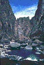
Prepare yourself for 2,000 ft, narrow canyon walls dropping almost vertically to the
Gunnison River. Many of the overlooks are easily accessed by car and very short walks.
Interpretive programs are offered all summer. Evening programs are presented at the South Rim campground, six nights per week. Nature walks are available daily.
![]()
Special Events Programs
Education Outreach designed to meet State of Colorado Content Standards. Preschool through post-baccalaureate programs offered.
![]()
Adjacent Visitor Attractions
When snow closes the South Rim Road, the NPS plows to the South Rim visitor center only, to allow cross-country skiing activity. Previously closed in winter, the visitor center is now open all year.
Back to Park Details List
Top of Page
National Parks Home