Neahkahnie Mountain (Neah-Kah-Nie) is a popular hike on the Oregon Coast between Cannon Beach and Manzanita. It’s a year-round hike although it’s going to be wet and cold if you hike it in the winter months. The view from the summit looks south toward Manzanita and includes the Oregon Coast Range mountains, the long sandy beach (Neahkahnie Beach), Newhalem Bay, and the Pacific Ocean. It is quite a sight to see and a perfect reward for a steep day hike.
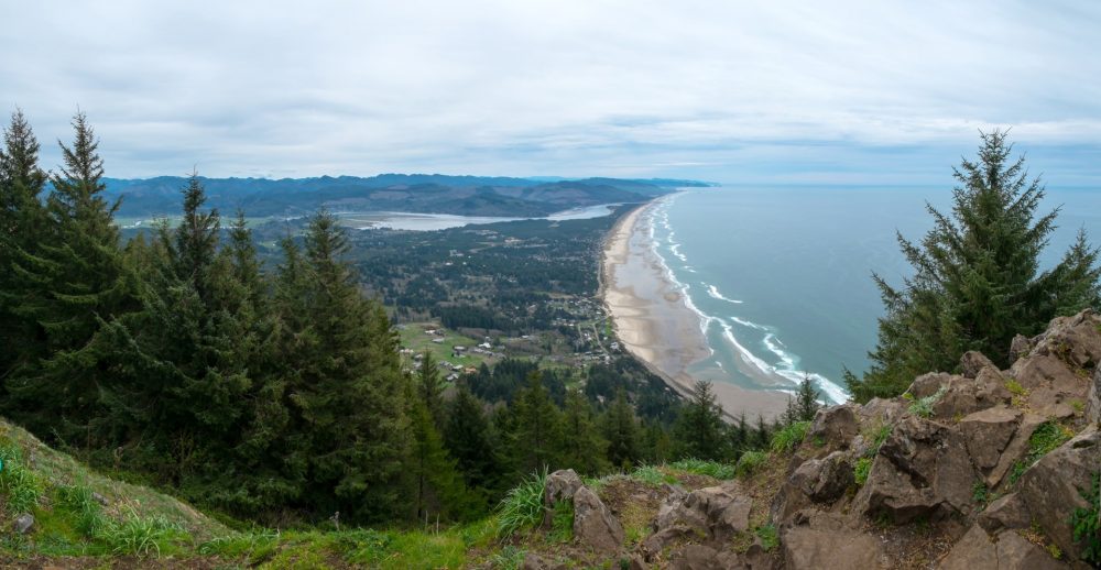 View from the summit of Neahkahnie Mountain
There are two trailheads (see the map above) so it is possible to hike over the mountain instead of just hiking out and back. You’ll need to arrange a shuttle vehicle at the trailhead you end at to make the point to point hike work out. You wouldn’t want to walk back via Highway 101. The elevation gain is lower from the south trailhead. From there you’ll gain about 900 feet vs about 1250 at the north trailhead on 101. The free topo map of Neahkahnie Mountain on Topozone shows the elevation contours and the trail very clearly.
If you are looking for more hiking trails to explore, the Elk Flats Trail begins at the northern trailhead parking lot and heads west to another stunning viewpoint which looks out over the ocean from a cliff edge. The mountain and coastal trail are both part of Oswald West State Park.
Mountains on this map
| Mountain | Elevation |
|---|---|
| Neahkahnie Mountain | 1,631 ft (497 m) |
Landmarks on this map
|
Neah-Kah-Nie Mountain South Trailhead The south trailhead is located at the end of the narrow Neahkahnie Mountain Road which begins across from the Neah-Kah-Nie Meadow housing community and is clearly signed. See details |
|
Neah-Kah-Nie Mountain North Trailhead Look for parking on the ocean side of Oregon Coast Highway (Hwy 101) just north of the trailhead. See details |