
A Tour of the North Ridge Route on Mount Everest
|
|
Climbing the North Side of
Everest
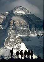
The North Side of Everest is drained by the Rongbuk Glacier system which
flows north around Changtse, the "North Peak" of Everest. Changtse is
linked to Everest by a saddle, the North Col, which is about 7000 meters
(around 23,000').
The climbing routes from the North Side are:
Of all the above routes, the only one that has had more than a just a
couple ascents (some have had only one) is the North Ridge from the North
Col. This route was attempted by the British (a la Mallory and Irvine) a
number of times in the 20's and 30's and was finally climbed by the
Chinese in 1960 and again in 1965. It has seen a number of successful
ascents in the 80's and 90's since China again began allowing western
climbers to climb Everest from Tibet in 1980.
Tibetan yaks and yak drivers are hired from some of the villages down
valley to assist in establishing Advance Base Camp at 21,500', to the east
of the North Col on the East Rongbuk Glacier. Most teams put in one or two
camps between BC and ABC, so often ABC is referred to as Camp III. It is
about 12 miles of rugged hiking from BC to ABC, mostly bouldery moraine and
some snow and ice. The yaks have to carry all their yak food with them.
It is great acclimatization, and after you do the trip a couple times, you
really start to feel strong and in great shape for the climbing above. This is a lot different than getting your
butt kicked in the Khumbu Ice Fall -- the first place you set foot above Base Camp on the Nepal side.
Since the wind is generally from west to east, the slopes leading to the Col from Camp III are lee slopes which means they accumulate snow deposits. This is generally not a big problem in the spring season (very little snow on the mountain), but you got to be brain dead to want to climb up to the Col in the autumn season. In fact there have been quite a number of deaths here from avalanches in the autumn season (and very few successful ascents from the North at all then). The Camp at the North Col (Camp IV) is again extremely windy. We use nets over our tents, anchored independently, to guarantee a good nights sleep (if your tent blows away at night you are dead meat).
The route to Camp V (about 25,600') is not too steep, mainly snow up to 25,000'
then snow and rock on up to the camp. The problem again is the wind. It
really rips through here. On both our '91 and '94 trips, we put fixed rope
every inch of the way so you could get down if it was blowing 80mph (I'm
not exaggerating). Also, even though it is not too steep, a slip would mean
a fast trip to the Rongbuk. Without oxygen, moving steadily with a
reasonable pack, the trip to Camp V takes about 7 hours. It's a beat-out no
matter how you cut it.
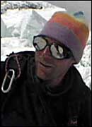
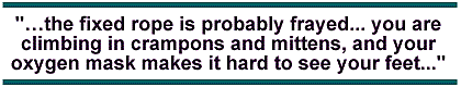
Strangely, the wind often diminishes above Camp V, since the North Ridge merges into the North Face and a "wind shadow" effect develops. The climb from V to VI (Camp VI is at about 27,200') is really cool. Snow, rock, ice, nothing too hard, but always good for maintaining your attention. There is fixed rope along the way, mainly to help you find the right route (a lot of rather devious ledges and snow patches). By this time, most people will be climbing on oxygen (maybe at 2-3 LPM). If you are moving strongly, you can do it in a half a day, no problem. If you are slow, that's a big clue that you should probably be going the other direction. Camp VI is another one of those camps with not much room. Maybe you can get four or five tents there if you really work at it (chop, dig, chop, dig). Look for the old destroyed tents... they make the best tent anchors (one persons garbage is another's treasure). Before you go to bed, find the start of the fixed ropes leading up through the Yellow Band... you don't want to be groping around in the dark trying to find the start of the route the next morning. Summit day on the North Ridge is where the rubber hits the road. Up to here, if everything has been going ok, you can probably get yourself up and down with a bit of luck. Above Camp VI, you got to be able to climb. I don't mean this facetiously. I mean that there is a long way to go to get to the top, a lot of different kinds of terrain, a long time to be spent at extreme altitude, and if you have a problem, you are toast. No rescue. Period. In '91 we left Camp VI at 3am. It takes a couple hours to get up through the Yellow Band in the dark. In places it is steep. You are by yourself -- everyone spreads out on the fixed ropes so several of you aren't bouncing on the same shitty anchor. When you hit the Northeast Ridge, you get the big view of Makalu and Kangchenjunga, and hopefully, some sunshine (you are probably pretty cold up to here). You better make damn sure you put in a marker here so that coming down late in the day (maybe in whiteout or dark) you can find the right place to drop off the ridge down through the Yellow Band (if you want to find Camp VI again). From the ridge crest to the First Step is easy scree/slab terraces. Easy to get lost on in a whiteout, too. Better put in some markers. The First Step is about 100 feet high, maybe fourth class rock with snow on it. Not too tough except the fixed rope is probably frayed, and you don't want to put much weight on it, you are climbing in crampons and mittens, and your oxygen mask makes it hard to see your feet. Good idea to have some extra rope with you so you can re-fix it for rappelling back down. Above the First Step is some mixed climbing, not hard, then a WILD knife edge that you walk across that leads to the old Camp VII site (not used anymore). On your left is the entire Kangshung Face, on the right the whole North Face... each way, about 10,000' down. This is a problem spot if the wind is blowing hard. Beyond Camp VII is the traverse to the Second Step. Again, it is probably third or fourth class rock, not difficult, except that with snow on the rock (in the shade... cold), and incredible exposure (10,000' plus) at your feet, it is intimidating. The Second Step itself is third/fourth class rock and steep snow/ice, over 100' high, with this crazy 15-foot ladder pasted to the top of the Step with some nasty pitons driven halfway in. The thing is dead vertical, and tends to twist when you are halfway up. There are usually some ropes of dubious quality hanging down that you can put a jumar on if you feel lucky. (I remember in '91 when I got to the top, I found the "anchor" to be one knife-blade piton, driven halfway in, with the fixed rope tied to the eye). I pulled it out with one hand and reset it with my hammer, adding a backup pin. When you get to the top of the Second Step, you think you got the summit in the bag, but it is still a long way. A long scree terrace leads you to the "Third Step," which is an awkward blob of rock on the ridge that you can climb directly or go around on steep snow. We found the snow here to be slabby and spooky. Above the Third Step is a steep snow triangle that was again either slabby or icy, definitely steep enough to send you all the way to the Central Rongbuk if your cramponing technique was lacking. Finally, you exit the snow onto the North Face, crossing a long narrow ledge which leads to a rock groove that finally takes you up to the summit ridge. Another couple hundred yards of ridge (with some wicked cornices and weird bumps and curves), and we were on top. We got to the top at 1pm and spent five minutes, took a couple shots, and got the hell out of there. By then it was snowing hard, complete whiteout, and getting real breezy. We had good goggles, plenty of O2, and had marked the hell out of the route on the way up. We had also fixed the First Step, the knife-edge and Second Step Traverse on the way up. We had extra rope for fixing the steep North Face summit groove on the way down, as well as the Third Step. We belayed down the summit snow triangle. In short... we were ready, and we cruised down with no problem. What could have been a real epic turned into an interesting afternoon in the mountains. In fact, four of the six of us went all the way to Camp V, arriving by headlamp about 10pm because we felt good and didn't want to spend another night at Camp VI. Looking back on our climb of the North Ridge, I see we were both lucky and well prepared. We did our best to minimize the hazards. Nonetheless, there were a thousand different spots where if someone had screwed up, they would have been dead. As I said before, there was no chance of rescue at any point on summit day. There was no way we could have carried someone down if they had been hurt. That's the name of the game up there. I just hope we can do as well this year. If you haven't thought seriously that you could die up there then you should consider a different sport. -- Eric Simonson, Mountain Zone Contributor
From The Mountain Zone Bookstore
|
|||||||


[Everest Home] [Climbing Home]