Death Valley Dayhikes
Go to Map
Go to Hikes
Hiking at low elevations during the summer is not recommended. Always carry water, even in the winter. Avoid hiking in canyons during heavy rains because of potential flash flood danger. Do not remove any natural or cultural features from the park.
Top of Page

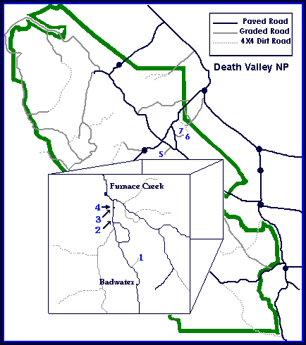
Roads (See Map Above for Location)
1) Natural Bridge Canyon:
- Length: 1 mile, round-trip.
- Starting Point: Natural Bridge parking area, Badwater Road.
- Description: Moderate uphill walk through narrow canyon. Large natural bridge at 0.3 mi. Trail ends at dry waterfall.
2) Desolation Canyon:
- Length: 1 mile, one-way.
- Starting Point: End of left fork Desolation Canyon Road, (not marked, look closely for it) 3.7 miles south of Hwy. 190 on Badwater road.
- Description: Narrow canyon through colorful badlands. From road's end, drop into main wash heading south. Hike up canyon, keeping to right at the forks.
3) Golden Canyon Interpretive Trail:
- Length: 1 mile, one-way.
- Starting Point: Golden Canyon parking area, Badwater Road.
- Description: Easy, self-guided trail through colorful canyon. Red Cathedral located 0.5 mile up canyon from last numbered trail marker. Trail guides are available for 50 cents on site or at park visitor centers.
4) Gower Gulch Loop
- Length: 5.5 miles round-trip.
- Starting Point: Golden Canyon parking area, Badwater Road.
- Description: Colorful badlands, canyon narrows, old borax mines. Hike up Golden Canyon to last numbered trail marker, then take path over badlands to Gower Gulch. Hike up to Zabriskie Point or down gulch to finish loop. Two easy dryfalls must be scrambled down in Gower Gulch. Ask for the Gower Gulch handout in Visitor Center.
- Moderate hike.
5) Salt Creek Interpretive Trail
- Length: 0.5 mile round-trip.
- Starting Point: Salt Creek parking area, 1 mile off Hwy. 190, 13.5 miles north of Furnace Creek.
- Description: Easy, self guided trail on a boardwalk over small stream. Good for viewing rare pupfish and other wildlife. Best in late winter/early spring. Trail guides available on site or at park visitor centers for 50 cents.
6) Keane Wonder Mine Trail
- Length: 1 mile, one-way.
- Starting Point: Keane Wonder Mill parking area, 2 miles off Beatty Cutoff road.
- Description: Very steep, narrow trail from mill ruins to mine 1500 ft. above. Sweeping views of Death Valley.
- Do not enter any mines - they are unstable and hazardous.
- Do not remove any historical artifacts.
7) Keane Wonder Springs
- Length: 1 mile, one-way.
- Starting Point: Keane Wonder Mill parking area, 2 miles off Beatty Cutoff road.
- Description: Follow pipeline north along mountain base to sulfur springs and travertine mounds. Beyond springs are remains of an old stampmill and cabin.
- Do not remove any historical artifacts.
8) Sand Dunes
- Length: 2 miles, one-way.
- Starting Point: Sand Dunes parking area, 2.2 miles east of Stovepipe Wells, Hwy 190.
- Description: Graceful desert dunes, numerous animal tracks. Walk cross-country to 120 ft. high dunes. Best in morning or afternoon for dramatic light. Also good for full moon hikes.
9) Mosaic Canyon
- Length: 2 miles, one-way.
- Starting Point: Mosaic Canyon parking area, 2 miles from Stovepipe Wells.
- Description: Popular, easy walk up narrow, polished marble-walled canyon. Some slickrock scrambling necessary. "Mosaics" of fragments of rocks cemented together can be seen in canyon walls. Bighorn sheep sighted occasionally.
10) Titus Canyon Narrows
- Length: 1.5 miles, one-way.
- Starting Point: Titus Canyon Mouth parking area, 3 miles off Scotty's Castle road on graded dirt road.
- Description: Easy access to lower Titus Canyon road. Follow gravel road up wash 1.5 mi. through narrows or continue to Klare Springs and petroglyphs at 6.5 miles.
- No camping allowed.
11) Little Hebe Crater Trail
- Length: 0.5 mile, one-way.
- Starting Point: Ubehebe Crater parking area, 8 miles west of Scotty's Castle.
- Description: Volcanic craters and elaborate erosion. Hike along west rim of Ubehebe Crater to Little Hebe and several older craters. Continue around Ubehebe's rim for loop hike.
12) Ubehebe Peak Trail
- Length: 3 miles, one-way.
- Starting Point: Grandstand parking area, Racetrack Road (high-clearance, 2WD or 4WD at times)
- Description: Peak forming west rim of Racetrack Valley in the Last Chance Range. Steep, narrow switchbacking trail with a 1800 ft. elevation gain. No trail exists for the last 0.4 mile to summit, so route-finding ability is necessary. Spectacular views of Racetrack and Saline Valleys.
Adventurous Hikes:
No trails. Rock scrambling... you're on your own!
13) Coffin Peak
- Length: 1.2 mile, one-way.
- Starting Point: Dante's View road, 0.5 mile before you reach the viewpoint itself. Park at the pullout with pit toilets and picnic table.
- Description: Short, cross-country hike. Walk over small hill NE paralleling the road. Proceed SE on ridge, over two rocky hills, then descend NE to a saddle before climbing one more hill. Once over this hill, you can see the cone-shaped summit of Coffin Peak. Follow ridgeline to east side of peak where a faint trail takes you to the summit. Spectacular views of Death Valley, Greenwater Valley and the Black Mountains.
- NO TRAIL
14) DeathValley Buttes
- Length: 1.8 mile, one-way.
- Starting Point: Hell's Gate parking area, 22 miles NE of Furnace Creek.
- Description: Short but strenuous scramble to the two prominent hills at the foot of the Grapevine Mountains. From Hell's Gate, walk SW 0.5 mile toward the buttes. Scramble south up the ridge to the first of the buttes. You made it! Now you can decide whether you want to attempt #2. It's more difficult. If so, descend carefully down the ridge 300 ft., then climb the narrow ridge to butte #2. Extreme care should be used when climbing the buttes. Ridges are narrow and exposed with steep drop-offs. Windy days make this effect quite dramatic. The views are among the best in Death Valley.
- NO TRAIL
15) Corkscrew Peak
- Length: 4 miles one-way.
- Starting Point: 1 mile east of Hell's Gate at Corkscrew Peak sign, Daylight Pass Road.
- Description: So you think you're going to make it to the top...we'll see. A peak composed of very folded rocks at the south end of the Grapevine Mountains. Strenuous, cross-country hike from road with a 3,000 ft. elevation gain. DO NOT head straight for the peak. Hike toward the right or east side, making your way up toward the peak and finally scaling peak by a narrow path on east side. Steep with unstable rocks. Topo maps are advised. Watch for a faint trail with some rock cairns. Good luck.
- NO TRAIL
16) Fall Canyon
- Length: 3.5 miles, one-way.
- Starting Point: Titus Canyon Mouth parking area, 3 miles off Scotty's Castle road.
- Description: Deep and spectacular canyon north of Titus Canyon. Walk 0.5 mile north along base of mountains to large wash, then 2.5 mi. up canyon to a 35 ft. dryfall. Using caution, you can climb around the falls on the south side. This will give you access to some of the most beautiful narrows in Death Valley. You can follow the canyon up another 4 or 5 miles.
17) Red Wall Canyon
- Length: 3 miles, one-way.
- Starting Point: Scotty's Castle Road, 3.8 miles north of Titus Canyon road exit.
- Description: Colorful (red) narrow mountain canyon. From road, hike 2 miles up alluvial fan to mouth of canyon (watch for meeting of red and black rock to locate canyon). Rock climbing skills are needed to continue beyond a dry waterfall 1 mile up the canyon.
- NO TRAIL
18) Little Bridge Canyon
- Length: 3 miles, one-way.
- Starting Point: 3 miles east of Stovepipe Wells Village, Hwy 190. Park along side of road, (first major canyon east of Grotto Canyon).
- Description: Ascend alluvial fan 2 miles south of road to canyon mouth. The canyon is very wide at first before narrowing. A small arch appears on the right 1/2 mile into the canyon and a 20 ft high natural bridge spans the east side of the canyon 1/2 mile further on. White quartzite canyon walls and interesting side canyons to explore. Canyon narrows further up from bridge.
- NO TRAIL
Summer Hikes:
Ideas of cool places to hike when the Valley gets too hot.
19) Wildrose Peak Trail:
- Length: 4.2 miles, one-way.
- Starting Point: Charcoal Kilns parking area, upper Wildrose Canyon Road.
- Description: A good high peak to climb (9,064 ft.). Trail begins at north end of kilns with an elevation gain of 2,200 ft. Spectacular views beyond 2 mile point. Steep grade for last mile.
20) Telescope Peak Trail: