Death Valley Backcountry Roads
Go to Map
Go to Roads
Death Valley has many unpaved backcountry roads. A vehicle with high-clearance will be necessary for all of the roads described below, but four wheel-drive may also be required to traverse some of the rougher roads. Please inquire at the Furnace Creek Visitor Center or other ranger stations for additional information and current road conditions. Backcountry camping is restricted to certain areas. Please check in at the Visitor Center before planning an overnight trip. Be sure to carry plenty of water; never rely on backcountry water sources. Please stay on established roads and drive carefully.
Top of Page

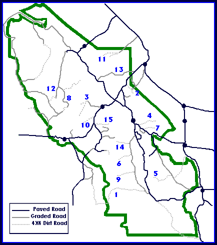
Roads (See Map Above for Location)
1) Butte Valley via Warm Springs:
- (21 miles)
- Heading west off of the West Side Road, this road follows Warm Springs Canyon past several talc mines before leading into scenic Butte Valley, at an elevation of 4500'. (4X4 required beyond mines) A rough road leads out of the park over Mengle Pass and into Panamint Valley to the west via Goler Wash.
- No Camping First 2 Miles.
2) Chloride City:
- (14 miles)
- This is one of the earliest sites of mining in Death Valley and can be reached via two roads. The rougher, but more interesting, route leaves the highway between Hell's Gate and Daylight Pass. After passing Monarch Canyon, 4X4 is required. No Camping First 2 Miles. The alternate road is located just beyond the park boundary east of Daylight Pass.
- Continue one mile south of the site of Chloride City for a spectacular view into Death Valley at Chloride Cliff.
3) Cottonwood / Marble Canyons:
- (13 miles Marble Canyon; 18 miles Cottonwood Canyon)
- The road begins east of the Stovepipe Wells airstrip and travels up the broad alluvial fan before reaching the canyon mouth. 8 miles in, the road drops into the wash and becomes rocky and rough. One mile past the end of the first narrows, a side road leads up Marble Canyon. Hikers can continue up this canyon beyond road's end to see some of the finest canyon narrows in the park. At the road's end up Cottonwood Canyon is a flowing stream lined with cottonwood trees. Please remember, camping is not permitted within 1/4 mile from any water source in Death Valley National Park.
- No Camping First 8 Miles.
4) Echo Canyon:
- (10 miles)
- The road begins two miles east of Furnace Creek Inn along Highway 190. The road tends to have deep gravel and is quite rocky 3 miles from the highway (4X4 required). The Needle's Eye, a natural arch, is located within the canyon narrows. The Inyo Mine is up the right fork 9 miles in and contains several old structures and remnants of mining equipment. The left fork continues past other old mines eventually becoming very rough 4x4 and exiting the park in Nevada.
- No Camping First 2 Miles.
5) Gold Valley:
- (26 miles from Dante's View Road)
- To access this road, travel 13 miles south on the Greenwater Valley Road from the paved Dante's View Road. The road into Gold Valley (4X4 required) leads off to the west, climbs over a pass in the Black Mountains, and drops into mountain-rimmed Gold Valley. The road ends at the spring in Willow Canyon.
- Camp at least 200 yards from any water source.
6) Hanaupah Canyon:
- (9 miles from West Side Road)
- This canyon drains from the park's highest elevation 11,049 ft. Telescope Peak. The road climbs the huge alluvial fan before dropping into the gravel wash at the canyon's mouth 5 miles in (4X4 recommended in wash). Follow the south fork of the canyon to road's end, downstream from Hanaupah Springs. Hikers can continue past the end of the road.
- Camp at least 200 yards from any water source.
- No Camping First 2 Miles.
7) Hole-in-the-Wall:
- (4 miles to the "hole"; 8 miles to road's end)
- The road begins 5.5 miles east of Furnace Creek Inn on Hwy. 190 and traverses east up a rugged gravel wash. After passing through the 400' deep gap called Hole-in-the-Wall, the road becomes rougher (4x4 required).
- No Camping First 2 Miles.
8) Hunter Mountain / Hidden Valley:
- (17.5 miles to old monument boundary)
- From Teakettle Junction the road becomes rougher and high clearance is required. At the junction 3.2 miles in, the left fork (NE) continues 10 miles to White Top Mountain. The right fork leads one mile up to the Lost Burro Mine. The main road continues through Hidden Valley passing several abandoned mining areas on the way to Hunter Mountain. From here it is another 23 miles to Hwy. 190.
- (4x4 required to drive over Hunter Mountain).
9) Johnson Canyon:
- (10 miles from West Side Road)
- Beyond the end of the road a 1.5 mile hike leads up the canyon to Hungry Bill's Ranch, with its rock-walled terraces and fruit trees. Continue on foot up the south fork another 1/2 mile to several old mining prospects.
- No Camping First 2 Miles.
10) Lemoigne Canyon:
- (4.4 miles)
- This extremely rough road (4X4 required) starts 6 miles west of Stovepipe Wells. Crossing an alluvial fan with numerous washes, the mouth of the canyon is reached in 4.4 miles. Vehicle travel beyond this point is not allowed.
- No Camping First 2 Miles.
11) Phinney Canyon:
- (22 miles)
- The road begins 11.7 miles north of Beatty, Nevada on Highway 95. Heading west across Sarcobatus Flats, the road forks in 12 miles to Strozzi Ranch on the left, and to Phinney Canyon on the right. Pinyon pine woodlands appear after the canyon is entered, and the road quickly becomes 4X4. From the pass there are views of the Grapevine Mountains high country and glimpses of the Sierra Nevada Range.
12) Racetrack / Teakettle Junction:
- (22 miles to Teakettle Junction; 28 miles to the Racetrack)
- The road begins at Ubehebe Crater and ends at the Racetrack playa, an ancient lakebed famous for its "moving rocks". Although this road is often passable to 2-wheel-drive, conditions can vary. From Teakettle Junction, a road leads south and west through Hidden Valley, over Hunter Mountain, and finally to Highway 190.
- No Camping Along Racetrack Road.
13) Titus Canyon:
- (27 miles)
- This popular road is ONE-WAY from east to west. To find the beginning of the drive, follow the highway toward Beatty, Nevada. Turn left 2.7 miles east of the park boundary. The road re-enters the park and winds through the Grapevine Mountains, then drops down through one of Death Valley's most spectacular canyons. Along the way watch for the ghost town of Leadfield and petroglyphs at Klare Spring. A self-guided booklet describing geology and trip highlights can be purchased at the visitor center.
- Although this road is often passable to 2-wheel-drive vehicles, conditions can vary, so check at a visitor center for current road conditions.
- No Camping Along Titus Canyon Road.
14) Trail Canyon:
- (12 miles from West Side Road)
- Climbing up the eastern flank of the Panamint Mountains, this road leads to a spring and old mining area at the forks of the canyon. Although some old maps show the road connecting with the Aguereberry Point road, that section was officially closed to vehicle traffic after a wash-out made it impassable.
- No Camping First 2 Miles.
15) Tucki Mine Road:
- (2.5 miles to Telephone Canyon fork, 10 miles to Tucki Mine)
- The road begins 1.7 miles up Wildrose Road from Emigrant Junction. At the mouth of Emigrant Canyon the road can be seen climbing up the bank on the other side. After crossing the slope to Telephone Canyon and climbing up it, the canyon forks. The old road up the right fork has been closed to vehicle traffic, but a short walk up it will bring you to a natural arch and an old mill site. The road continues up the left fork to the Tucki mine.
- No Camping First 2 Miles.
Top of Page
Death Valley Home
National Parks Home