
Back to the Pub
See Also:
Marketplace
Hiking Home
Contest
Auctions
Expedition News

![]()

Gerry McGirr, Assistant ODP Training Manager, Lothian University Hospitals Trust
|
|
 click |
We decided to ascend the Ben via the classic route of Carn Mor Dearg followed by a traverse of the Ar�te, a high, level, exposed ridge which connects the summit with the northeast buttress of the Ben. In summer the CMD Arete, as it is otherwise known, is long and testing. In winter, it is particularly serious, but in all seasons it requires great care.
Ben Nevis is always referred to by climbers simply as 'The Ben' (Ben meaning mountain). Ben Nevis is Britain's highest mountain at 1344m/4409ft, falling short of the permanent snowline only by a few hundred feet. The mountain is mainly made up of black lava which forms the great cliffs with granite forming the 'gentler' slopes. The first detailed map of the Scottish highlands drawn by Timothy Point in 1595, shows the mountain as 'Ben Novesh.' The name, Ben Nevis, comes from a Gaelic word 'neimheas,' meaning venomous or evil one. In the 1600s it was known as Bin Nevis, and a century later it was called Ben Nevis.
Our base was Fort William on the west coast of Scotland. The provisional date for the climb was Saturday, 17 July. The Ben was there, but Fort William was covered by a cloud base of 600 feet with winds reaching 40mph and heavy rain. That was the situation for the rest of the day. The weather forecast for Sunday did not sound encouraging: the cloud base at 3000 feet with rain spreading from the west followed by fog.
|
|
|
|
|
|
|
|
| "One or two glasses of the water of life, Freedom and Whisky gang thegither as Burns would say..." |
|
|
|
|
|
|
|
|
On Sunday we had an early rise. Unfortunately the clouds were reluctant to rise as we were. This was due to gluttony on Saturday evening: the consumption of 8oz fillet steaks and a small quantity of grape juice, followed by one or two glasses of the water of life, Freedom and Whisky gang thegither as Burns would say. What followed was engrossed dialogue on the finer points of some of Scotland's great mountains, days spent, and experiences met well into the wee small hours before retiring from the evening.
The forecast on Sunday was almost correct: cloud base 3000 feet. Encouragingly, the wind was light, around 20mph, and as yet no signs of fog.
On reaching Achintee Farm, we both made the decision to ascend the Ben. If we reached the Arete and conditions became too dangerous or visibility so bad, we would call it off. You have to expect bad weather on the Ben. On Saturday, word reached Fort William that a climber had been killed in the northern highlands—this being one of the main reason why we sat out the storm in Fort William on Saturday.
As proper equipment, clothing, a compass, and map are essential on all of the mountains around Fort William, the Ben is no exception. The ascent we were embarking on not only requires a head for heights but requires low winds, good visibility, and in poor visibility competent navigational skills. Ben Nevis has many bad accident blackspots, none more so than Five Finger Gully and Gardyloo Gully. They claim numerous casualties every year from walkers to climbers, and as it happens, both gullyies would be on our approach.
|
|
|
|
|
|
|
|
| "We set out from Achintee Farm and minutes into the walk became aware of the flight of the midge..." |
|
|
|
|
|
|
|
|
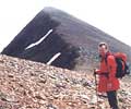
We set out from Achintee Farm and minutes into the walk became aware of the flight of the midge. Previous days of rain had brought them out of their dwellings and on kamikaze runs. We met the busy path that leads to Lochan Meall and t-Suide at (711m), otherwise known as the 'Halfway Lochan,' and continued due north into the glen of the Allt a' Mhuillin. Just as well, as the tourist path was playing host to a procession of people, some very ill-equipped for their expedition. Just before we entered the great glen of Allt a' Muillin, the great cliffs of the Ben on our right made us look very pocket-sized. This mountain, early into our ascent, was given the respect it duly deserved. It was not long before the Ben gave us a small taste of what it possesses.
We left the path as it turned right into Coire Leis and descended down heathery slopes. Looking at my altimeter, we had lost 1000 feet. This was the first mental low point of the day. All this height would have to be regained.
We crossed the Allt a' Mhuillin stream, which at this time of the year was flowing fast due to the amount of rainfall this part of the country was receiving. Some suggest it's the El Niño effect, I call it good old Scottish summer weather. This was our first stop of the day, mainly for nourishment and rehydration. We filled our bottles from the burn; it would be 4 hours or more before we could replenish our flasks. The importance of hydration during exercise such as this can not be emphasized enough. Heat exhaustion must be avoided at all cost.
|
|
 click |
The ascent of Carn Dearg Meadhonach was remorseless but the views of Coire Leis, the forbidding massif of the Ben's northeast face, and the calm feng-shui of serenity across Loch Eil in the west more than compensated. For both of us, the Scottish Highlands and Islands have always given rise to the most majestic and transcendent of human passion for our country. This view will stay with us for many years to come.
We were very reluctant to leave this privileged viewpoint, especially with the weather we were now experiencing. After some rehydration, we set off again towards the Arete truly inspired and fired with enthusiasm. Piers summed it all up: 'God's Country.' Unaware that he had a PhD in theology, I was very impressed. It would not be the last time I was to hear this saying. However his language was slightly different during the ascent of Carn Mor Meadhonach. Was the feng-shui having an effect?
|
|
|
|
|
|
|
|
| "The Arete is a magnificent traverse of exposure which manifests itself in a show of solidarity..." |
|
|
|
|
|
|
|
|
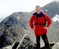
From Carn Dearg Meadhonach, we continued south-southeast across a short dip to Carn Mor Dearg beyond which the ridge narrows to form the Arete. The Arete is a magnificent traverse of exposure which manifests itself in a show of solidarity between Carn Mor Dearg and the great northeast ridge.
As we began our careful traverse of the Arete it became distinctly obvious why this is the only way to ascend the Ben, 'Gods Country.' The Arete heads the rim of Coire Leis, and the northeast face of the Ben overwhelms you. Looking down into Coire Leis, the eye finds it difficult to spot the CIC hut. Sadly it can't be missed due to the pile of bright orange cylinders that litters the view.
About 2000 feet below us, we were reminded how much respect this area should be given. The RAF were flying their yellow Sea King helicopter through Glen Nevis. A few days later we found out that someone had been airlifted—off the tourist path of all places.
Once on the Arete, it soon becomes clear why a head for heights is required. A quick glance to your right reveals the worse prospect, little room for error, a fast descent into Coire Leis if you get it wrong.
|
|
 click |
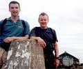
We arrived on the summit at 5pm to be greeted by a sea of tourists wearing everything from designer jeans to the latest fashion in Reeboks...not quite what we had in mind. The perfect reward on reaching the summit was not the tourists but the clear skies and panoramic views. The summit of the Ben contains the ruins of an observatory and the highest war memorial in the UK.
We snapped the traditional summit photograph, and after a quick cuppa, we began our descent via the monotonous tourist path picking up our steps back from the Halfway Lochan. It became quite clear to us why the tourist path should be missed at all cost. On the ascent of the CMD Arete, we met 4 people. The tourist path was like Oxford Street during the January sales. We recommend avoiding it even on the descent, by going back down the Arete or heading back over Lochan Meall and t-Suide, coming out at the Distillery.
|
|
|
|
|
|
|
|
| "On the ascent of the CMD Arete, we met 4 people. The tourist path was like Oxford Street during the January sales..." |
|
|
|
|
|
|
|
|
We are already planning a one day ascent of Scotland's second, third, and fourth highest mountains, Ben Macdui (4295ft), Cairn Toul (4242ft), and Braeriach (4252ft). This will be next years fund raiser for REACT.
Both of us would like to thank all our family friends and work colleagues for the support and sponsorship received and pay a big thanks to our main sponsor, Medic International, in Edinburgh who made a particularly generous donation to our cause. Without all your support and without all your kind donations, we could not have expected to come this far. We hope the money raised will go in some way to help the families and children who need it most.
— Gerry McGirr, MountainZone.com Pubster
[Back to the Pub]