The Battle for The Bears Ears, Part I: The Legislative Landscape
![]() Andrew Weber |
Backpacking, Canyoneering, Hiking, Outdoor News, Traveling |
2,012 views
Andrew Weber |
Backpacking, Canyoneering, Hiking, Outdoor News, Traveling |
2,012 views
This is the first installment of a series of articles examining protection of Cedar Mesa and the proposed Bears Ears National Monument.
On a clear day, the Bears Ears offer nothing but peace. The twin buttes stand eerily silent in the thin air, rippled only by a whispering breeze or the cries of a lazy raven riding an updraft. A vast landscape of desert wilderness stretches out below, empty of human presence.
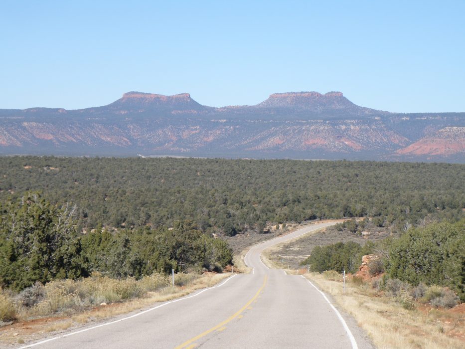 Bears Ears Buttes from Utah 261
This is the heart of southeastern Utah’s canyon country, where time, wind, and water have peeled back the strata of the Colorado Plateau to reveal its core. Layers of red and yellow sandstone lie sculpted and crumbled into a maze of cliffs, mesas, buttes, and canyons. Pastel-green forests of pinyon, juniper, and sage cover the highlands. Snowy peaks provide an enticing mirage under the desert sun.
The serenity is an illusion. All around, a war is being fought.
According to Friends of Cedar Mesa, a non-profit advocacy group from the nearby town of Bluff, this is “America’s most significant unprotected landscape.” It’s also the most contentious. The Friends are part of a coalition that seeks federal legislation to turn approximately 1.9 million acres of this remote corner of San Juan County, Utah, into the Bears Ears National Monument.
Related: Bears Ears National Monument Map
On the other side stand an array of conservative forces, including most local residents. To them any federal action would amount to a massive land grab: an attempt to seal off the countryside from a range of beneficial uses. In a state where 67% of the land is already owned by the federal government, new “protection” means the loss of freedom, economic opportunity, and a way of life that has sustained their community for generations.
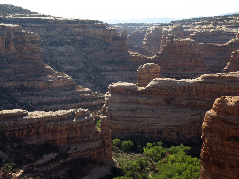
The heart of the proposed monument is Cedar Mesa: a 1,000-square-mile plateau incised by Grand Gulch and its tributary canyons as they wind their way to the narrow gorge of the San Juan River, 3,000 feet below. Archaeologist Nels C. Nelson visited the mesa in 1920 and described it as “One of the least frequented and… most inaccessible parts of the United States.” He would still recognize it today.
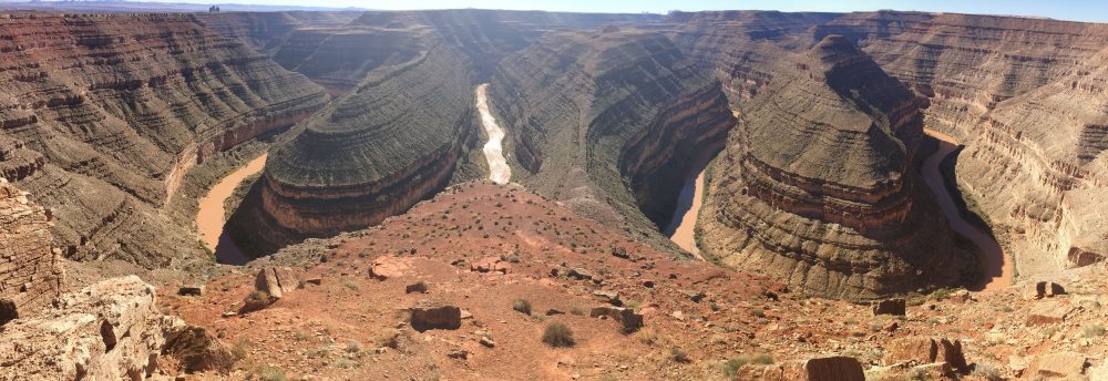 Goosenecks of the San Juan River
Only two paved roads cross the mesa. Utah Highway 95 hugs the foot of Elk Ridge and the Red House Cliffs on its northern edge, and Utah 261 climbs up from Valley of the Gods on gravel switchbacks and then bisects the mesa along its central spine, dividing its eastern and western watersheds. Travel is so difficult here that much of 95 follows the track of the first Mormon settlers, who fought their way across the rugged landscape in the winter of 1880 on the Hole-in-the-Rock Expedition. No better east-west route has been found since.
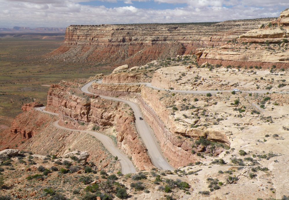 Utah 261 on the Cedar Mesa rim
The Hole-in-the-Rock Mormons settled on Cedar Mesa’s eastern flank, establishing the isolated towns of Bluff and Montezuma Creek. Their lives on the frontier were demanding and unforgiving. Paid work was scarce and unreliable in the cash-poor economy. Ranching and farming were difficult and unpredictable in the arid, high-desert environment, where temperatures could soar into the 100s in summer yet drop below freezing for weeks in the winter. Mining was dangerous and brutal.
But the settlers soon made a valuable discovery: the canyons were rife with ancient rock art, ruins, and artifacts, left behind by the people they called the Cliff Dwellers.
Abandoned structures stood neatly in shaded alcoves along the canyon bottoms, under the rims, and on ledges so high and precipitous they were impossible to reach. Prehistoric symbols decorated the canyon walls, often cryptic to modern viewers, but sometimes more recognizable: successful hunts, flourishing crops, people in ceremonial garb. Scattered everywhere were woven baskets, ornate pottery, and a host of other tools, weapons, and articles of clothing that were pieces of art in their own right.
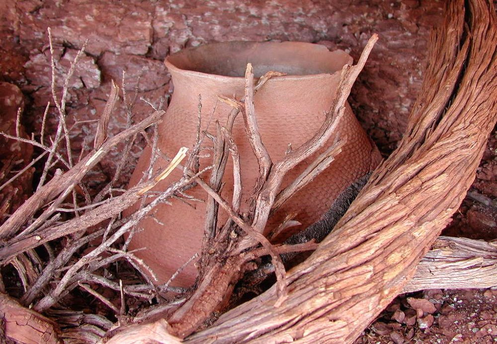 Pot, Mesa Verde Corrugated Style, ~1200 A.D., in situ on Cedar Mesa
For people in a constant struggle to survive, no opportunity could be ignored; ancient artifacts could be gathered and sold for cash.
Artifact collection was initially focused out of southwest Colorado, only 75 miles away. Colorado had achieved statehood in 1876 and was more developed than the Utah Territory, which would not become a state for another two decades. The railroad had reached the town of Durango, Colorado, in 1881, creating an easy link to the outside world and allowing items to be shipped to wealthy buyers in the east. Colorado’s canyons also harbored archaeological riches of their own.
A who’s who of early cowboys-turned-southwest-archaeologists led these ventures: McLoyd, Kidder, Graham, and, most famously, the five Wetherill brothers. The Wetherills were five ranchers from Mancos, Colorado, who dug for antiquities whenever they could escape the demands of their cattle operations. Professional archaeologists soon followed, hiring the same local cowboys as guides.
Scandinavian naturalist Gustaf Nordenskiold arrived at the Wetherill ranch in 1891, captivated by the items he had seen in a Denver exhibition and determined to see their source firsthand. Working with John and Richard Wetherill he made a professional excavation of Cliff Palace, the largest cliff dwelling known with more than 150 rooms.
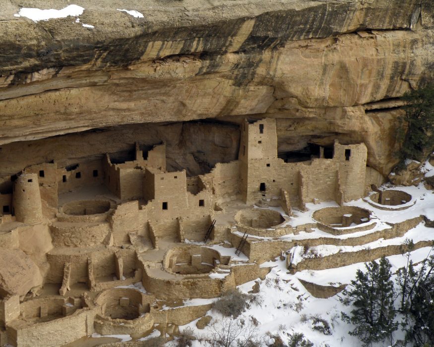 Cliff Palace in winter, Mesa Verde National Park
However, many Durango residents were outraged when Nordenskiold loaded crates of relics onto a train for shipment to Europe. He was arrested and jailed, until it was determined he had broken no laws. Powerless to stop him, locals looked on in vain as The Denver and Rio Grande Railroad pulled out of the station. Nordenskiold and his vast collection escaped to Finland.
The public outcry over the theft of artifacts from public lands increased over the next decade, sparking demand for legislative action. In 1906, Teddy Roosevelt secured passage of The Antiquities Act, which gave the President the authority to create National Monuments on public lands to protect “Historic landmarks, historic and prehistoric structures, and other objects of historic or scientific interest.” Colorado’s Mesa Verde, home to Cliff Palace and hundreds of other prehistoric archaeological sites, was established as a National Park soon after.
With a stroke of a pen, Roosevelt had shielded Mesa Verde from the illegal excavator’s shovel. But the President did not choose to defend Cedar Mesa, despite its similar value and history of exploitation. When Friends of Cedar Mesa describe the landscape as “unprotected,” it’s this historical oversight they bring to light.
That oversight led to Illicit removal of artifacts continuing unchecked at Cedar Mesa for decades. It was not until 1971 that any further legal action was taken and Grand Gulch was declared a Primitive Area under the jurisdiction of the Bureau of Land Management, a designation similar to Wilderness on other federal lands. A team of less than ten rangers, now mostly seasonal volunteers, was stationed on the mesa as well.
 Grand Gulch, main channel
This protection has proven inadequate. A handful of volunteers with no law-enforcement authority can only make a minimal impact. Some areas of the mesa might see a ranger visit once per year; others might never be patrolled at all.
In the face of this limited deterrent, Cedar Mesa’s cultural heritage has continued to deteriorate and has lost unfathomable value through the years. Rock art sites have been vandalized, ancient grave sites desecrated, and thousands of treasures dug up and hauled away. Those missing artifacts now lie in the hands of unauthorized private traders and collectors, or are lost forever.
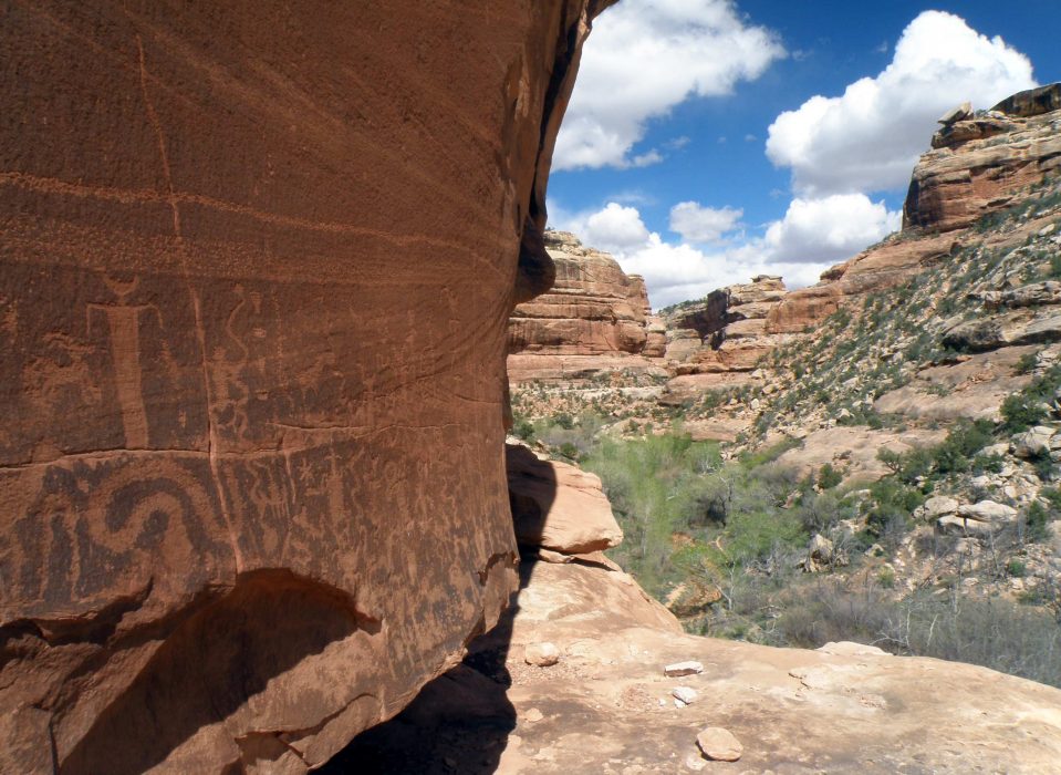 Ancient petroglyphs, Cedar Mesa canyon
Most of this looting was initiated by locals, already intimate with the land. They had lived on it for generations and traced their ancestry back to the first settlers. They knew the countryside and all of its secrets, and saw themselves as participating in a traditional activity, similar to the cowboys of the 19th century.
The new hub of the looting was Blanding, Utah, informally known to many archaeologists as the pot-hunting capital of the southwest. In 2009, the FBI descended on the town to arrest multiple residents for their involvement in a substantial illegal-artifact trade network. The resulting fallout, including three suicides, left deep scars in the community. It also magnified local suspicion and outright hatred of the Federal Government.
Not that anti-government sentiment was previously hard to find; Mormons in the Utah Territory had gone to war with the United States Government in 1857, and old habits die hard. The Utah Legislature is currently at the forefront of a movement – the so-called Sagebrush Rebellion – among many western states to seize control of federally-owned lands within their borders.
This is far from fertile territory for the establishment of any new federal land jurisdiction. Yet the perceived threat that President Obama will invoke the unilateral power provided by the Antiquities Act to create a Bears Ears Monument has brought Utah legislators to the negotiating table, hoping to find a compromise solution.
U.S. Congressional representatives Rob Bishop and Jason Chaffetz, both Utah Republicans, now lead a Public Lands Initiative, “To build consensus among stakeholders in eastern Utah to designate lands for conservation and development.” The political conflict over ownership and exploitation of the land has lasted for more than a century, but this might be its pivotal point.
The battle lines are drawn over two competing ideas of what needs protection: the land itself or a way of life that depends on it. These two ideas cannot easily coexist on the same piece of ground.
The Bears Ears quietly await a resolution.
Read the entire The Battle for The Bears Ears series:
- Part I: The Legislative Landscape
- Part II: The End of Obscurity
- Part III: Road Wars
- Part IV: The Trouble With Archaeology
- Part V: A Personal View
Related Articles
 My First Trip to Winthrop and the Methow Valley The snow began falling as we hit Pateros and climbed the Methow Valley Highway. The […] Posted in Traveling
 Frames by 2DeepMedia https://vimeo.com/174683600
Eddie Foster is a storyteller. He is poetic, emotive, and […] Posted in Videos
Frames by 2DeepMedia https://vimeo.com/174683600
Eddie Foster is a storyteller. He is poetic, emotive, and […] Posted in Videos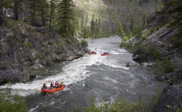 Middle Fork of the Salmon River Rafting Rafts running Pistol Creek (IV). Photo: Zachary Collier @ NWRC
The Middle Fork of the […] Posted in Whitewater, Fly Fishing, Hot Springs
Middle Fork of the Salmon River Rafting Rafts running Pistol Creek (IV). Photo: Zachary Collier @ NWRC
The Middle Fork of the […] Posted in Whitewater, Fly Fishing, Hot Springs